Schmirn geodata
Schmirn (Tyrol) is a seat of a third-order administrative division; located in Austria in Europe/Vienna (GMT+2) time zone. In our database, there are 2958 cities with bigger population. Compared to other cities in Austria, 80.3% of cities are located further ↑North; 91.1% of cities are located further →East and 99.4% of cities have lower elevation than Schmirn. Note1
Administrative division(s):
- Level 1: Tyrol
- Level 2: Politischer Bezirk Innsbruck Land
- Level 3: Schmirn


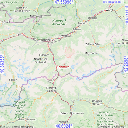
Schmirn GPS coordinates[2]
47° 4' 59.988" North, 11° 34' 0.012" East
| Map corner | latitude | longitude |
|---|---|---|
| Upper-left | 47.55996°, | 10.86355° |
| Center: | 47.08333°, | 11.56667° |
| Lower-right: | 46.6024°, | 12.2698° |
| Map W x H: | 106.5×106.5 km | = 66.2×66.2mi |
| max Lat: | 48.98333° ⇑80.3% North |
| Schmirn: | 47.08333° |
| min Lat: | ⇓19.7% South 46.48841° |
| min Long | Schmirn | max Long |
| 9.57802° | 11.56667° | 17.1° |
| W 8.9%⇐ | ⇒91.1% E |
Elevation
Elevation of Schmirn is 1436 m = 4711 ft, and this is 930.5 m = 3053 ft above average elevation for this country.
| Max E: |
2140 m = 7021 ft | 0.59999999999999% |
| Schmirn | 1436 m 4711 ft | |
| Avg. | 505.5 m = 1658 ft | |
Min E: |
118 m = 387 ft | 99.4% |
See also: Austria elevation on elevation.city.
Geographical zone
Schmirn is located in North temperate zone (between Tropic of Cancer and the Arctic Circle). Distance of this North polar circle is 2166 km =1345.9 mi to North.| Distance of | km | miles | from Schmirn |
|---|---|---|---|
| North Pole | 4771.9 | 2965.1 | to North |
| Arctic Circle | 2166 | 1345.9 | to North |
| Tropic Cancer | 2629.3 | 1633.8 | to South |
| Equator | 5235.2 | 3253 | to South |


Nearby cities:
15 places around Schmirn: (largest is in red/bold)
• Ausserweg
8.4 km =5.2 mi,  311°
311°
• Außerschmirn
2.5 km =1.6 mi,  270°
270°
• Ellbögen
12.8 km =8 mi,  316°
316°
• Gries am Brenner
8.2 km =5.1 mi,  232°
232°
• Matrei am Brenner
10 km =6.2 mi,  299°
299°
• Mauern
7.8 km =4.8 mi,  283°
283°
• Mühlbachl
10.4 km =6.5 mi, 302°
• Obernberg am Brenner
13.6 km =8.5 mi,  236°
236°
• Oberweg
6.7 km =4.2 mi,  325°
325°
• Pfons
10.3 km =6.4 mi, 309°
• Schöfens
9.9 km =6.2 mi, 305°
• Statz
9.6 km =6 mi,  292°
292°
• Steinach am Brenner
7.6 km =4.7 mi, 270°
• Trins
11.4 km =7.1 mi, 270°
• Vals
5 km =3.1 mi,  211°
211°
Sources, notices
• [Note1] Compared only with cities in Austria existing in our database
• [Src1] Map data: © OpenStreetMap contributors (CC-BY-SA)
• [Src2] Other city data from geonames.org with taken over terms of usage.
• [Src3] Geographical zone / Annual Mean Temperature by Robert A. Rohde @ Wikipedia
