Yanchep geodata
Yanchep (Western Australia) is a section of populated place; located in Australia in Australia/Perth (GMT+8) time zone. With population of 8,571 people, there are 752 cities with bigger population in this country. Compared to other cities in Australia, 69.6% of cities are located further ↓South; 98.6% of cities are located further →East and 80.4% of cities have higher elevation than Yanchep. Note1


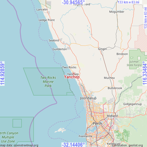
Yanchep GPS coordinates[2]
31° 32' 48.408" South, 115° 37' 54.156" East
| Map corner | latitude | longitude |
|---|---|---|
| Upper-left | -30.94565°, | 114.92859° |
| Center: | -31.54678°, | 115.63171° |
| Lower-right: | -32.14406°, | 116.33484° |
| Map W x H: | 133.3×133.3 km | = 82.8×82.8mi |
| max Lat: | -10.58257° ⇑30.4% North |
| Yanchep: | -31.54678° |
| min Lat: | ⇓69.6% South -43.31423° |
| min Long | Yanchep | max Long |
| 113.53327° | 115.63171° | 153.61246° |
| W 1.4%⇐ | ⇒98.6% E |
Elevation
Elevation of Yanchep is 15 m = 49 ft, and this is 107 m = 351 ft below average elevation for this country.
| Max E: |
1715 m = 5627 ft | 80.4% |
| Avg. | 122 m = 400 ft | |
| Yanchep | 15 m = 49 ft | |
Min E: |
-2 m = -7 ft | 19.6% |
See also: Australia elevation on elevation.city.
Geographical zone
Yanchep is located in South temperate zone (between Tropic of Capricorn and the Antarctic Circle). Distance of this Southern Tropic circle is 901.8 km =560.4 mi to North.| Distance of | km | miles | from Yanchep |
|---|---|---|---|
| Equator | 3507.7 | 2179.6 | to North |
| Tropic Capricorn | 901.8 | 560.4 | to North |
| Antarctic Circle | 3893.5 | 2419.3 | to South |
| South Pole | 6499.4 | 4038.5 | to South |


Nearby cities:
15 places around Yanchep: (largest is in red/bold)
• Alkimos
10.6 km =6.6 mi,  150°
150°
• Banksia Grove
23.3 km =14.5 mi,  135°
135°
• Burns Beach
21.1 km =13.1 mi,  156°
156°
• Butler
12.7 km =7.9 mi, 147°
• Carramar
20.7 km =12.9 mi, 140°
• Clarkson
17.5 km =10.9 mi, 149°
• Eglinton
7 km =4.3 mi,  129°
129°
• Iluka
23 km =14.3 mi, 155°
• Jindalee
12.9 km =8 mi, 152°
• Kinross
21.6 km =13.4 mi, 152°
• Merriwa
15.2 km =9.4 mi, 149°
• Mindarie
17.4 km =10.8 mi, 155°
• Quinns Rocks
15.7 km =9.8 mi, 154°
• Ridgewood
15.4 km =9.6 mi, 145°
• Two Rocks
6.7 km =4.2 mi,  321°
321°
Sources, notices
• [Note1] Compared only with cities in Australia existing in our database
• [Src1] Map data: © OpenStreetMap contributors (CC-BY-SA)
• [Src2] Other city data from geonames.org with taken over terms of usage.
• [Src3] Geographical zone / Annual Mean Temperature by Robert A. Rohde @ Wikipedia
