Carramar geodata
Carramar (Western Australia) is a section of populated place; located in Australia in Australia/Perth (GMT+8) time zone. With population of 7,002 people, there are 979 cities with bigger population in this country. Compared to other cities in Australia, 68.9% of cities are located further ↓South; 96.8% of cities are located further →East and 56.3% of cities have lower elevation than Carramar. Note1


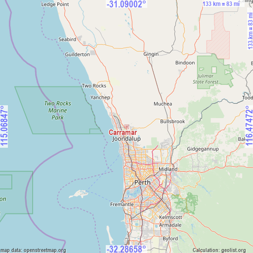
Carramar GPS coordinates[2]
31° 41' 24.828" South, 115° 46' 17.724" East
| Map corner | latitude | longitude |
|---|---|---|
| Upper-left | -31.09002°, | 115.06847° |
| Center: | -31.69023°, | 115.77159° |
| Lower-right: | -32.28658°, | 116.47472° |
| Map W x H: | 133×133 km | = 82.6×82.6mi |
| max Lat: | -10.58257° ⇑31.1% North |
| Carramar: | -31.69023° |
| min Lat: | ⇓68.9% South -43.31423° |
| min Long | Carramar | max Long |
| 113.53327° | 115.77159° | 153.61246° |
| W 3.2%⇐ | ⇒96.8% E |
Elevation
Elevation of Carramar is 56 m = 184 ft, and this is 66 m = 217 ft below average elevation for this country.
| Max E: |
1715 m = 5627 ft | 43.7% |
| Avg. | 122 m = 400 ft | |
| Carramar | 56 m = 184 ft | |
Min E: |
-2 m = -7 ft | 56.3% |
See also: Australia elevation on elevation.city.
Geographical zone
Carramar is located in South temperate zone (between Tropic of Capricorn and the Antarctic Circle). Distance of this Southern Tropic circle is 917.7 km =570.2 mi to North.| Distance of | km | miles | from Carramar |
|---|---|---|---|
| Equator | 3523.6 | 2189.5 | to North |
| Tropic Capricorn | 917.7 | 570.2 | to North |
| Antarctic Circle | 3877.6 | 2409.4 | to South |
| South Pole | 6483.4 | 4028.6 | to South |


Nearby cities:
15 places around Carramar: (largest is in red/bold)
• Ashby
5.3 km =3.3 mi,  152°
152°
• Banksia Grove
3.2 km =2 mi,  101°
101°
• Burns Beach
5.9 km =3.7 mi,  235°
235°
• Clarkson
4.5 km =2.8 mi,  280°
280°
• Connolly
6.8 km =4.2 mi,  197°
197°
• Currambine
5.3 km =3.3 mi,  205°
205°
• Iluka
6.4 km =4 mi,  217°
217°
• Joondalup
6 km =3.7 mi,  182°
182°
• Kinross
4.5 km =2.8 mi, 224°
• Merriwa
6.2 km =3.9 mi,  296°
296°
• Mindarie
6.1 km =3.8 mi,  270°
270°
• Quinns Rocks
6.7 km =4.2 mi,  285°
285°
• Ridgewood
5.6 km =3.5 mi, 304°
• Sinagra
6.7 km =4.2 mi, 150°
• Tapping
4 km =2.5 mi, 145°
Sources, notices
• [Note1] Compared only with cities in Australia existing in our database
• [Src1] Map data: © OpenStreetMap contributors (CC-BY-SA)
• [Src2] Other city data from geonames.org with taken over terms of usage.
• [Src3] Geographical zone / Annual Mean Temperature by Robert A. Rohde @ Wikipedia
