Clarkson geodata
Clarkson (Western Australia) is a populated locality; located in Australia in Australia/Perth (GMT+8) time zone. With population of 12,599 people, there are 377 cities with bigger population in this country. Compared to other cities in Australia, 69% of cities are located further ↓South; 98% of cities are located further →East and 63.7% of cities have higher elevation than Clarkson. Note1


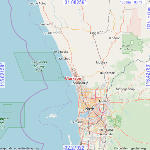
Clarkson GPS coordinates[2]
31° 40' 58.152" South, 115° 43' 28.92" East
| Map corner | latitude | longitude |
|---|---|---|
| Upper-left | -31.08256°, | 115.02158° |
| Center: | -31.68282°, | 115.7247° |
| Lower-right: | -32.27922°, | 116.42783° |
| Map W x H: | 133.1×133.1 km | = 82.7×82.7mi |
| max Lat: | -10.58257° ⇑31% North |
| Clarkson: | -31.68282° |
| min Lat: | ⇓69% South -43.31423° |
| min Long | Clarkson | max Long |
| 113.53327° | 115.7247° | 153.61246° |
| W 2%⇐ | ⇒98% E |
Elevation
Elevation of Clarkson is 28 m = 92 ft, and this is 94 m = 308 ft below average elevation for this country.
| Max E: |
1715 m = 5627 ft | 63.7% |
| Avg. | 122 m = 400 ft | |
| Clarkson | 28 m = 92 ft | |
Min E: |
-2 m = -7 ft | 36.3% |
See also: Australia elevation on elevation.city.
Geographical zone
Clarkson is located in South temperate zone (between Tropic of Capricorn and the Antarctic Circle). Distance of this Southern Tropic circle is 916.9 km =569.7 mi to North.| Distance of | km | miles | from Clarkson |
|---|---|---|---|
| Equator | 3522.8 | 2189 | to North |
| Tropic Capricorn | 916.9 | 569.7 | to North |
| Antarctic Circle | 3878.4 | 2409.9 | to South |
| South Pole | 6484.3 | 4029.2 | to South |


Nearby cities:
15 places around Clarkson: (largest is in red/bold)
• Alkimos
6.9 km =4.3 mi,  328°
328°
• Banksia Grove
7.7 km =4.8 mi,  101°
101°
• Burns Beach
4.2 km =2.6 mi,  185°
185°
• Butler
4.8 km =3 mi,  336°
336°
• Carramar
4.5 km =2.8 mi, 100°
• Connolly
7.7 km =4.8 mi,  161°
161°
• Currambine
6 km =3.7 mi, 158°
• Iluka
5.9 km =3.7 mi,  174°
174°
• Jindalee
4.7 km =2.9 mi,  322°
322°
• Kinross
4.2 km =2.6 mi, 162°
• Merriwa
2.3 km =1.4 mi, 330°
• Mindarie
1.8 km =1.1 mi,  246°
246°
• Quinns Rocks
2.2 km =1.4 mi,  296°
296°
• Ridgewood
2.4 km =1.5 mi,  355°
355°
• Tapping
7.8 km =4.8 mi,  121°
121°
Sources, notices
• [Note1] Compared only with cities in Australia existing in our database
• [Src1] Map data: © OpenStreetMap contributors (CC-BY-SA)
• [Src2] Other city data from geonames.org with taken over terms of usage.
• [Src3] Geographical zone / Annual Mean Temperature by Robert A. Rohde @ Wikipedia
