Pickering Brook geodata
Pickering Brook (Western Australia) is a section of populated place; located in Australia in Australia/Perth (GMT+8) time zone. With population of 576 people, there are 4628 cities with bigger population in this country. Compared to other cities in Australia, 64.3% of cities are located further ↓South; 91.2% of cities are located further →East and 87.8% of cities have lower elevation than Pickering Brook. Note1


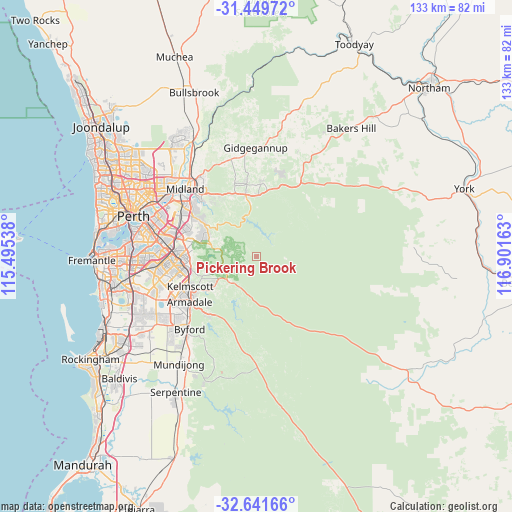
Pickering Brook GPS coordinates[2]
32° 2' 51.468" South, 116° 11' 54.6" East
| Map corner | latitude | longitude |
|---|---|---|
| Upper-left | -31.44972°, | 115.49538° |
| Center: | -32.04763°, | 116.1985° |
| Lower-right: | -32.64166°, | 116.90163° |
| Map W x H: | 132.5×132.5 km | = 82.3×82.3mi |
| max Lat: | -10.58257° ⇑35.7% North |
| Pickering Brook: | -32.04763° |
| min Lat: | ⇓64.3% South -43.31423° |
| min Long | Pickering Brook | max Long |
| 113.53327° | 116.1985° | 153.61246° |
| W 8.8%⇐ | ⇒91.2% E |
Elevation
Elevation of Pickering Brook is 308 m = 1010 ft, and this is 186 m = 610 ft above average elevation for this country.
| Max E: |
1715 m = 5627 ft | 12.2% |
| Pickering Brook | 308 m 1010 ft | |
| Avg. | 122 m = 400 ft | |
Min E: |
-2 m = -7 ft | 87.8% |
See also: Australia elevation on elevation.city.
Geographical zone
Pickering Brook is located in South temperate zone (between Tropic of Capricorn and the Antarctic Circle). Distance of this Southern Tropic circle is 957.4 km =594.9 mi to North.| Distance of | km | miles | from Pickering Brook |
|---|---|---|---|
| Equator | 3563.4 | 2214.2 | to North |
| Tropic Capricorn | 957.4 | 594.9 | to North |
| Antarctic Circle | 3837.8 | 2384.7 | to South |
| South Pole | 6443.7 | 4003.9 | to South |


Nearby cities:
15 places around Pickering Brook: (largest is in red/bold)
• Bickley
10.1 km =6.3 mi,  301°
301°
• Carmel
9.9 km =6.2 mi,  290°
290°
• Darlington
18.1 km =11.2 mi,  322°
322°
• Glen Forrest
16.7 km =10.4 mi,  328°
328°
• Gooseberry Hill
17.5 km =10.9 mi,  306°
306°
• Kalamunda
15.6 km =9.7 mi, 301°
• Kelmscott
18.4 km =11.4 mi,  242°
242°
• Lesmurdie
15 km =9.3 mi, 289°
• Mahogany Creek
16.8 km =10.4 mi,  339°
339°
• Martin
14.8 km =9.2 mi,  257°
257°
• Mundaring
16.4 km =10.2 mi,  349°
349°
• Orange Grove
18.3 km =11.4 mi,  276°
276°
• Roleystone
14.2 km =8.8 mi, 238°
• Sawyers Valley
16.2 km =10.1 mi,  0°
0°
• Walliston
13 km =8.1 mi, 295°
Sources, notices
• [Note1] Compared only with cities in Australia existing in our database
• [Src1] Map data: © OpenStreetMap contributors (CC-BY-SA)
• [Src2] Other city data from geonames.org with taken over terms of usage.
• [Src3] Geographical zone / Annual Mean Temperature by Robert A. Rohde @ Wikipedia
