Kalamunda geodata
Kalamunda (Western Australia) is a seat of a second-order administrative division; located in Australia in Australia/Perth (GMT+8) time zone. With population of 6,744 people, there are 1019 cities with bigger population in this country. Compared to other cities in Australia, 65.5% of cities are located further ↓South; 91.7% of cities are located further →East and 87.1% of cities have lower elevation than Kalamunda. Note1


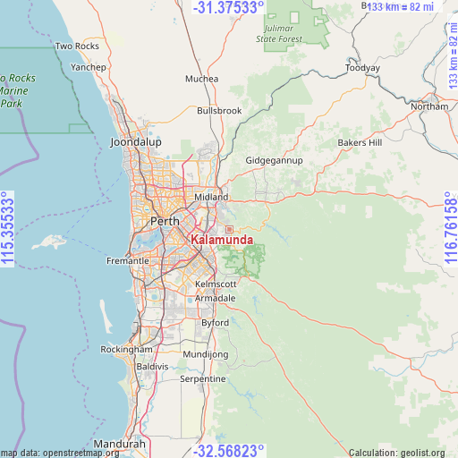
Kalamunda GPS coordinates[2]
31° 58' 25.392" South, 116° 3' 30.42" East
| Map corner | latitude | longitude |
|---|---|---|
| Upper-left | -31.37533°, | 115.35533° |
| Center: | -31.97372°, | 116.05845° |
| Lower-right: | -32.56823°, | 116.76158° |
| Map W x H: | 132.6×132.6 km | = 82.4×82.4mi |
| max Lat: | -10.58257° ⇑34.5% North |
| Kalamunda: | -31.97372° |
| min Lat: | ⇓65.5% South -43.31423° |
| min Long | Kalamunda | max Long |
| 113.53327° | 116.05845° | 153.61246° |
| W 8.3%⇐ | ⇒91.7% E |
Elevation
Elevation of Kalamunda is 289 m = 948 ft, and this is 167 m = 548 ft above average elevation for this country.
| Max E: |
1715 m = 5627 ft | 12.9% |
| Kalamunda | 289 m 948 ft | |
| Avg. | 122 m = 400 ft | |
Min E: |
-2 m = -7 ft | 87.1% |
See also: Australia elevation on elevation.city.
Geographical zone
Kalamunda is located in South temperate zone (between Tropic of Capricorn and the Antarctic Circle). Distance of this Southern Tropic circle is 949.2 km =589.8 mi to North.| Distance of | km | miles | from Kalamunda |
|---|---|---|---|
| Equator | 3555.1 | 2209 | to North |
| Tropic Capricorn | 949.2 | 589.8 | to North |
| Antarctic Circle | 3846 | 2389.8 | to South |
| South Pole | 6451.9 | 4009 | to South |


Nearby cities:
15 places around Kalamunda: (largest is in red/bold)
• Bickley
5.4 km =3.4 mi,  122°
122°
• Boya
6 km =3.7 mi,  359°
359°
• Carmel
6.2 km =3.9 mi,  140°
140°
• Darlington
6.4 km =4 mi,  19°
19°
• Forrestfield
5 km =3.1 mi,  258°
258°
• Glen Forrest
7.6 km =4.7 mi,  37°
37°
• Gooseberry Hill
2.3 km =1.4 mi,  337°
337°
• Hazelmere
7.7 km =4.8 mi,  324°
324°
• Helena Valley
6.3 km =3.9 mi, 343°
• High Wycombe
6.1 km =3.8 mi,  302°
302°
• Koongamia
7.6 km =4.7 mi,  348°
348°
• Lesmurdie
3.3 km =2.1 mi,  197°
197°
• Maida Vale
3.8 km =2.4 mi,  309°
309°
• Walliston
3 km =1.9 mi,  149°
149°
• Wattle Grove
6.6 km =4.1 mi,  236°
236°
Sources, notices
• [Note1] Compared only with cities in Australia existing in our database
• [Src1] Map data: © OpenStreetMap contributors (CC-BY-SA)
• [Src2] Other city data from geonames.org with taken over terms of usage.
• [Src3] Geographical zone / Annual Mean Temperature by Robert A. Rohde @ Wikipedia
