Castletown geodata
Castletown (Western Australia) is a section of populated place; located in Australia in Australia/Perth (GMT+8) time zone. With population of 3,901 people, there are 1823 cities with bigger population in this country. Compared to other cities in Australia, 52.9% of cities are located further ↑North; 88.9% of cities are located further →East and 91.8% of cities have higher elevation than Castletown. Note1


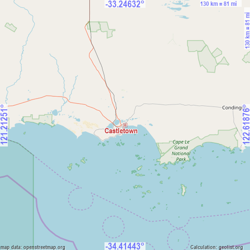
Castletown GPS coordinates[2]
33° 49' 56.532" South, 121° 54' 56.268" East
| Map corner | latitude | longitude |
|---|---|---|
| Upper-left | -33.24632°, | 121.21251° |
| Center: | -33.83237°, | 121.91563° |
| Lower-right: | -34.41443°, | 122.61876° |
| Map W x H: | 129.9×129.9 km | = 80.7×80.7mi |
| max Lat: | -10.58257° ⇑52.9% North |
| Castletown: | -33.83237° |
| min Lat: | ⇓47.1% South -43.31423° |
| min Long | Castletown | max Long |
| 113.53327° | 121.91563° | 153.61246° |
| W 11.1%⇐ | ⇒88.9% E |
Elevation
Elevation of Castletown is 8 m = 26 ft, and this is 114 m = 374 ft below average elevation for this country.
| Max E: |
1715 m = 5627 ft | 91.8% |
| Avg. | 122 m = 400 ft | |
| Castletown | 8 m = 26 ft | |
Min E: |
-2 m = -7 ft | 8.2% |
See also: Australia elevation on elevation.city.
Geographical zone
Castletown is located in South temperate zone (between Tropic of Capricorn and the Antarctic Circle). Distance of this Southern Tropic circle is 1155.9 km =718.2 mi to North.| Distance of | km | miles | from Castletown |
|---|---|---|---|
| Equator | 3761.8 | 2337.5 | to North |
| Tropic Capricorn | 1155.9 | 718.2 | to North |
| Antarctic Circle | 3639.4 | 2261.4 | to South |
| South Pole | 6245.3 | 3880.6 | to South |


Nearby cities:
15 places around Castletown: (largest is in red/bold)
• Boulder
341.5 km =212.2 mi,  353°
353°
• Broadwood
341 km =211.9 mi, 352°
• Coolgardie
327.9 km =203.7 mi, 347°
• Esperance
3.7 km =2.3 mi,  216°
216°
• Hopetoun
165.7 km =103 mi,  265°
265°
• Kambalda East
293 km =182.1 mi,  355°
355°
• Kambalda West
293.7 km =182.5 mi, 354°
• Lake Grace
330.2 km =205.2 mi,  284°
284°
• Norseman
182.2 km =113.2 mi, 355°
• Nulsen
4.6 km =2.9 mi,  233°
233°
• Pink Lake
5.6 km =3.5 mi,  247°
247°
• Ravensthorpe
175.1 km =108.8 mi, 279°
• Sinclair
5.3 km =3.3 mi, 229°
• Stoneville
330.1 km =205.1 mi, 357°
• West Beach
5.3 km =3.3 mi,  206°
206°
Sources, notices
• [Note1] Compared only with cities in Australia existing in our database
• [Src1] Map data: © OpenStreetMap contributors (CC-BY-SA)
• [Src2] Other city data from geonames.org with taken over terms of usage.
• [Src3] Geographical zone / Annual Mean Temperature by Robert A. Rohde @ Wikipedia
