Normanville geodata
Normanville (South Australia) is a populated place; located in Australia in Australia/Adelaide (GMT+10.5) time zone. With population of 1,589 people, there are 3200 cities with bigger population in this country. Compared to other cities in Australia, 76.9% of cities are located further ↑North; 85.2% of cities are located further →East and 63.7% of cities have higher elevation than Normanville. Note1


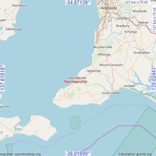
Normanville GPS coordinates[2]
35° 26' 46.428" South, 138° 19' 16.68" East
| Map corner | latitude | longitude |
|---|---|---|
| Upper-left | -34.87139°, | 137.61818° |
| Center: | -35.44623°, | 138.3213° |
| Lower-right: | -36.01699°, | 139.02443° |
| Map W x H: | 127.4×127.4 km | = 79.2×79.2mi |
| max Lat: | -10.58257° ⇑76.9% North |
| Normanville: | -35.44623° |
| min Lat: | ⇓23.1% South -43.31423° |
| min Long | Normanville | max Long |
| 113.53327° | 138.3213° | 153.61246° |
| W 14.8%⇐ | ⇒85.2% E |
Elevation
Elevation of Normanville is 28 m = 92 ft, and this is 94 m = 308 ft below average elevation for this country.
| Max E: |
1715 m = 5627 ft | 63.7% |
| Avg. | 122 m = 400 ft | |
| Normanville | 28 m = 92 ft | |
Min E: |
-2 m = -7 ft | 36.3% |
See also: Australia elevation on elevation.city.
Geographical zone
Normanville is located in South temperate zone (between Tropic of Capricorn and the Antarctic Circle). Distance of this Southern Tropic circle is 1335.3 km =829.7 mi to North.| Distance of | km | miles | from Normanville |
|---|---|---|---|
| Equator | 3941.3 | 2449 | to North |
| Tropic Capricorn | 1335.3 | 829.7 | to North |
| Antarctic Circle | 3459.9 | 2149.9 | to South |
| South Pole | 6065.8 | 3769.1 | to South |


Nearby cities:
15 places around Normanville: (largest is in red/bold)
• Aldinga
23.3 km =14.5 mi,  39°
39°
• Aldinga Beach
22.4 km =13.9 mi,  33°
33°
• Encounter Bay
29 km =18 mi,  119°
119°
• Hayborough
31.3 km =19.4 mi,  107°
107°
• Maslin Beach
28.4 km =17.6 mi, 30°
• McCracken
29.8 km =18.5 mi, 109°
• Moana
31.4 km =19.5 mi, 26°
• Mount Compass
29.3 km =18.2 mi,  67°
67°
• Myponga
14.4 km =8.9 mi, 70°
• Port Willunga
24.3 km =15.1 mi, 32°
• Seaford Rise
31.7 km =19.7 mi, 27°
• Sellicks Beach
16.5 km =10.3 mi, 43°
• Victor Harbor
29.5 km =18.3 mi, 113°
• Willunga
28.7 km =17.8 mi,  47°
47°
• Yankalilla
2.8 km =1.7 mi, 114°
Sources, notices
• [Note1] Compared only with cities in Australia existing in our database
• [Src1] Map data: © OpenStreetMap contributors (CC-BY-SA)
• [Src2] Other city data from geonames.org with taken over terms of usage.
• [Src3] Geographical zone / Annual Mean Temperature by Robert A. Rohde @ Wikipedia
