Mount Helena geodata
Mount Helena (Western Australia) is a section of populated place; located in Australia in Australia/Perth (GMT+8) time zone. With population of 3,070 people, there are 2215 cities with bigger population in this country. Compared to other cities in Australia, 67.2% of cities are located further ↓South; 91.2% of cities are located further →East and 86.8% of cities have lower elevation than Mount Helena. Note1


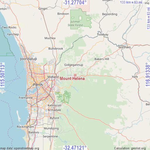
Mount Helena GPS coordinates[2]
31° 52' 33.816" South, 116° 12' 36.9" East
| Map corner | latitude | longitude |
|---|---|---|
| Upper-left | -31.27704°, | 115.50713° |
| Center: | -31.87606°, | 116.21025° |
| Lower-right: | -32.47121°, | 116.91338° |
| Map W x H: | 132.8×132.8 km | = 82.5×82.5mi |
| max Lat: | -10.58257° ⇑32.8% North |
| Mount Helena: | -31.87606° |
| min Lat: | ⇓67.2% South -43.31423° |
| min Long | Mount Helena | max Long |
| 113.53327° | 116.21025° | 153.61246° |
| W 8.8%⇐ | ⇒91.2% E |
Elevation
Elevation of Mount Helena is 282 m = 925 ft, and this is 160 m = 525 ft above average elevation for this country.
| Max E: |
1715 m = 5627 ft | 13.2% |
| Mount Helena | 282 m 925 ft | |
| Avg. | 122 m = 400 ft | |
Min E: |
-2 m = -7 ft | 86.8% |
See also: Australia elevation on elevation.city.
Geographical zone
Mount Helena is located in South temperate zone (between Tropic of Capricorn and the Antarctic Circle). Distance of this Southern Tropic circle is 938.4 km =583.1 mi to North.| Distance of | km | miles | from Mount Helena |
|---|---|---|---|
| Equator | 3544.3 | 2202.3 | to North |
| Tropic Capricorn | 938.4 | 583.1 | to North |
| Antarctic Circle | 3856.9 | 2396.6 | to South |
| South Pole | 6462.8 | 4015.8 | to South |


Nearby cities:
15 places around Mount Helena: (largest is in red/bold)
• Boya
15.2 km =9.4 mi,  251°
251°
• Chidlow
6.1 km =3.8 mi,  74°
74°
• Darlington
13.1 km =8.1 mi, 248°
• Gidgegannup
13.7 km =8.5 mi,  350°
350°
• Glen Forrest
10.8 km =6.7 mi,  243°
243°
• Greenmount
15.4 km =9.6 mi,  259°
259°
• Hovea
10.4 km =6.5 mi,  265°
265°
• Jane Brook
15.2 km =9.4 mi,  275°
275°
• Mahogany Creek
7.7 km =4.8 mi, 244°
• Mundaring
5 km =3.1 mi,  234°
234°
• Parkerville
6.8 km =4.2 mi, 271°
• Sawyers Valley
3.1 km =1.9 mi,  197°
197°
• Stoneville
3.7 km =2.3 mi, 266°
• Swan View
15.2 km =9.4 mi, 266°
• Wooroloo
12.6 km =7.8 mi,  50°
50°
Sources, notices
• [Note1] Compared only with cities in Australia existing in our database
• [Src1] Map data: © OpenStreetMap contributors (CC-BY-SA)
• [Src2] Other city data from geonames.org with taken over terms of usage.
• [Src3] Geographical zone / Annual Mean Temperature by Robert A. Rohde @ Wikipedia
