Gidgegannup geodata
Gidgegannup (Western Australia) is a section of populated place; located in Australia in Australia/Perth (GMT+8) time zone. With population of 2,651 people, there are 2466 cities with bigger population in this country. Compared to other cities in Australia, 68.6% of cities are located further ↓South; 91.2% of cities are located further →East and 81.9% of cities have lower elevation than Gidgegannup. Note1


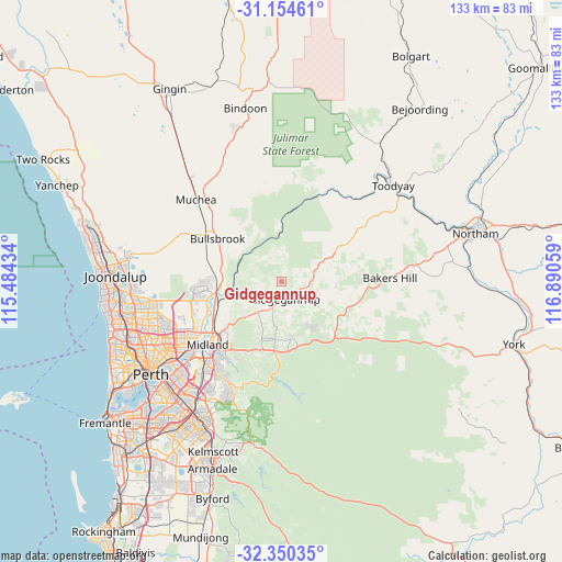
Gidgegannup GPS coordinates[2]
31° 45' 15.876" South, 116° 11' 14.856" East
| Map corner | latitude | longitude |
|---|---|---|
| Upper-left | -31.15461°, | 115.48434° |
| Center: | -31.75441°, | 116.18746° |
| Lower-right: | -32.35035°, | 116.89059° |
| Map W x H: | 133×133 km | = 82.6×82.6mi |
| max Lat: | -10.58257° ⇑31.4% North |
| Gidgegannup: | -31.75441° |
| min Lat: | ⇓68.6% South -43.31423° |
| min Long | Gidgegannup | max Long |
| 113.53327° | 116.18746° | 153.61246° |
| W 8.8%⇐ | ⇒91.2% E |
Elevation
Elevation of Gidgegannup is 203 m = 666 ft, and this is 81 m = 266 ft above average elevation for this country.
| Max E: |
1715 m = 5627 ft | 18.1% |
| Gidgegannup | 203 m 666 ft | |
| Avg. | 122 m = 400 ft | |
Min E: |
-2 m = -7 ft | 81.9% |
See also: Australia elevation on elevation.city.
Geographical zone
Gidgegannup is located in South temperate zone (between Tropic of Capricorn and the Antarctic Circle). Distance of this Southern Tropic circle is 924.8 km =574.6 mi to North.| Distance of | km | miles | from Gidgegannup |
|---|---|---|---|
| Equator | 3530.8 | 2193.9 | to North |
| Tropic Capricorn | 924.8 | 574.6 | to North |
| Antarctic Circle | 3870.4 | 2405 | to South |
| South Pole | 6476.3 | 4024.2 | to South |


Nearby cities:
15 places around Gidgegannup: (largest is in red/bold)
• Brigadoon
11 km =6.8 mi,  259°
259°
• Chidlow
14.3 km =8.9 mi,  145°
145°
• Herne Hill
17.5 km =10.9 mi,  243°
243°
• Hovea
16.5 km =10.3 mi,  209°
209°
• Mahogany Creek
17.5 km =10.9 mi,  195°
195°
• Millendon
15.4 km =9.6 mi,  247°
247°
• Morangup
13.7 km =8.5 mi,  45°
45°
• Mount Helena
13.7 km =8.5 mi,  170°
170°
• Mundaring
16.5 km =10.3 mi,  186°
186°
• Parkerville
14.2 km =8.8 mi, 199°
• Sawyers Valley
16.5 km =10.3 mi,  175°
175°
• Stoneville
13.9 km =8.6 mi, 186°
• The Vines
17.5 km =10.9 mi,  269°
269°
• Upper Swan
15.2 km =9.4 mi, 263°
• Wooroloo
13.1 km =8.1 mi,  114°
114°
Sources, notices
• [Note1] Compared only with cities in Australia existing in our database
• [Src1] Map data: © OpenStreetMap contributors (CC-BY-SA)
• [Src2] Other city data from geonames.org with taken over terms of usage.
• [Src3] Geographical zone / Annual Mean Temperature by Robert A. Rohde @ Wikipedia
