Meningie geodata
Meningie (South Australia) is a populated place; located in Australia in Australia/Adelaide (GMT+10.5) time zone. With population of 1,083 people, there are 3718 cities with bigger population in this country. Compared to other cities in Australia, 77.6% of cities are located further ↑North; 76.5% of cities are located further →East and 98.1% of cities have higher elevation than Meningie. Note1


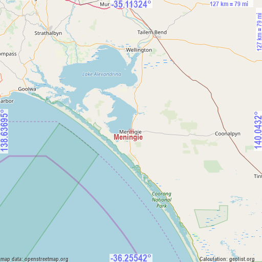
Meningie GPS coordinates[2]
35° 41' 10.932" South, 139° 20' 24.252" East
| Map corner | latitude | longitude |
|---|---|---|
| Upper-left | -35.11324°, | 138.63695° |
| Center: | -35.68637°, | 139.34007° |
| Lower-right: | -36.25542°, | 140.0432° |
| Map W x H: | 127×127 km | = 78.9×78.9mi |
| max Lat: | -10.58257° ⇑77.6% North |
| Meningie: | -35.68637° |
| min Lat: | ⇓22.4% South -43.31423° |
| min Long | Meningie | max Long |
| 113.53327° | 139.34007° | 153.61246° |
| W 23.5%⇐ | ⇒76.5% E |
Elevation
Elevation of Meningie is 4 m = 13 ft, and this is 118 m = 387 ft below average elevation for this country.
| Max E: |
1715 m = 5627 ft | 98.1% |
| Avg. | 122 m = 400 ft | |
| Meningie | 4 m = 13 ft | |
Min E: |
-2 m = -7 ft | 1.9% |
See also: Australia elevation on elevation.city.
Geographical zone
Meningie is located in South temperate zone (between Tropic of Capricorn and the Antarctic Circle). Distance of this Southern Tropic circle is 1362 km =846.3 mi to North.| Distance of | km | miles | from Meningie |
|---|---|---|---|
| Equator | 3968 | 2465.6 | to North |
| Tropic Capricorn | 1362 | 846.3 | to North |
| Antarctic Circle | 3433.2 | 2133.3 | to South |
| South Pole | 6039.1 | 3752.5 | to South |


Nearby cities:
15 places around Meningie: (largest is in red/bold)
• Goolwa
54.5 km =33.9 mi,  292°
292°
• Goolwa Beach
55.1 km =34.2 mi, 291°
• Goolwa North
52.4 km =32.6 mi, 294°
• Goolwa South
54 km =33.6 mi, 290°
• Hayborough
64.7 km =40.2 mi, 285°
• Hindmarsh Island
47 km =29.2 mi, 294°
• McCracken
66.2 km =41.1 mi,  284°
284°
• Middleton
60.8 km =37.8 mi, 288°
• Milang
45.5 km =28.3 mi,  312°
312°
• Murray Bridge
63.3 km =39.3 mi,  354°
354°
• Port Elliot
62.2 km =38.6 mi, 286°
• Riverglades
65.4 km =40.6 mi,  356°
356°
• Strathalbyn
62.4 km =38.8 mi,  319°
319°
• Tailem Bend
49.4 km =30.7 mi,  12°
12°
• Victor Harbor
66.7 km =41.4 mi, 283°
Sources, notices
• [Note1] Compared only with cities in Australia existing in our database
• [Src1] Map data: © OpenStreetMap contributors (CC-BY-SA)
• [Src2] Other city data from geonames.org with taken over terms of usage.
• [Src3] Geographical zone / Annual Mean Temperature by Robert A. Rohde @ Wikipedia
