Goolwa North geodata
Goolwa North (South Australia) is a populated place; located in Australia in Australia/Adelaide (GMT+10.5) time zone. With population of 951 people, there are 3894 cities with bigger population in this country. Compared to other cities in Australia, 77% of cities are located further ↑North; 77.2% of cities are located further →East and 96.8% of cities have higher elevation than Goolwa North. Note1


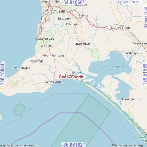
Goolwa North GPS coordinates[2]
35° 29' 28.248" South, 138° 48' 45.216" East
| Map corner | latitude | longitude |
|---|---|---|
| Upper-left | -34.91666°, | 138.10944° |
| Center: | -35.49118°, | 138.81256° |
| Lower-right: | -36.06162°, | 139.51569° |
| Map W x H: | 127.3×127.3 km | = 79.1×79.1mi |
| max Lat: | -10.58257° ⇑77% North |
| Goolwa North: | -35.49118° |
| min Lat: | ⇓23% South -43.31423° |
| min Long | Goolwa North | max Long |
| 113.53327° | 138.81256° | 153.61246° |
| W 22.8%⇐ | ⇒77.2% E |
Elevation
Elevation of Goolwa North is 5 m = 16 ft, and this is 117 m = 384 ft below average elevation for this country.
| Max E: |
1715 m = 5627 ft | 96.8% |
| Avg. | 122 m = 400 ft | |
| Goolwa North | 5 m = 16 ft | |
Min E: |
-2 m = -7 ft | 3.2% |
See also: Australia elevation on elevation.city.
Geographical zone
Goolwa North is located in South temperate zone (between Tropic of Capricorn and the Antarctic Circle). Distance of this Southern Tropic circle is 1340.3 km =832.8 mi to North.| Distance of | km | miles | from Goolwa North |
|---|---|---|---|
| Equator | 3946.2 | 2452.1 | to North |
| Tropic Capricorn | 1340.3 | 832.8 | to North |
| Antarctic Circle | 3454.9 | 2146.8 | to South |
| South Pole | 6060.8 | 3766 | to South |


Nearby cities:
15 places around Goolwa North: (largest is in red/bold)
• Encounter Bay
21.3 km =13.2 mi,  244°
244°
• Goolwa
3 km =1.9 mi,  247°
247°
• Goolwa Beach
3.9 km =2.4 mi, 247°
• Goolwa South
3.9 km =2.4 mi,  227°
227°
• Hayborough
15.3 km =9.5 mi, 253°
• Hindmarsh Island
5.4 km =3.4 mi,  112°
112°
• McCracken
17.1 km =10.6 mi, 253°
• Middleton
10.1 km =6.3 mi,  257°
257°
• Milang
17.1 km =10.6 mi,  57°
57°
• Mount Compass
23.7 km =14.7 mi,  312°
312°
• Myponga
32.4 km =20.1 mi,  287°
287°
• Port Elliot
12.8 km =8 mi, 250°
• Strathalbyn
26.7 km =16.6 mi,  15°
15°
• Victor Harbor
18.5 km =11.5 mi, 249°
• Willunga
33.9 km =21.1 mi,  316°
316°
Sources, notices
• [Note1] Compared only with cities in Australia existing in our database
• [Src1] Map data: © OpenStreetMap contributors (CC-BY-SA)
• [Src2] Other city data from geonames.org with taken over terms of usage.
• [Src3] Geographical zone / Annual Mean Temperature by Robert A. Rohde @ Wikipedia
