Strathalbyn geodata
Strathalbyn (South Australia) is a populated place; located in Australia in Australia/Adelaide (GMT+10.5) time zone. With population of 6,348 people, there are 1112 cities with bigger population in this country. Compared to other cities in Australia, 75.1% of cities are located further ↑North; 76.9% of cities are located further →East and 62.7% of cities have lower elevation than Strathalbyn. Note1


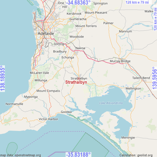
Strathalbyn GPS coordinates[2]
35° 15' 35.244" South, 138° 53' 32.892" East
| Map corner | latitude | longitude |
|---|---|---|
| Upper-left | -34.68363°, | 138.18935° |
| Center: | -35.25979°, | 138.89247° |
| Lower-right: | -35.83188°, | 139.5956° |
| Map W x H: | 127.7×127.7 km | = 79.3×79.3mi |
| max Lat: | -10.58257° ⇑75.1% North |
| Strathalbyn: | -35.25979° |
| min Lat: | ⇓24.9% South -43.31423° |
| min Long | Strathalbyn | max Long |
| 113.53327° | 138.89247° | 153.61246° |
| W 23.1%⇐ | ⇒76.9% E |
Elevation
Elevation of Strathalbyn is 72 m = 236 ft, and this is 50 m = 164 ft below average elevation for this country.
| Max E: |
1715 m = 5627 ft | 37.3% |
| Avg. | 122 m = 400 ft | |
| Strathalbyn | 72 m = 236 ft | |
Min E: |
-2 m = -7 ft | 62.7% |
See also: Australia elevation on elevation.city.
Geographical zone
Strathalbyn is located in South temperate zone (between Tropic of Capricorn and the Antarctic Circle). Distance of this Southern Tropic circle is 1314.6 km =816.9 mi to North.| Distance of | km | miles | from Strathalbyn |
|---|---|---|---|
| Equator | 3920.5 | 2436.1 | to North |
| Tropic Capricorn | 1314.6 | 816.9 | to North |
| Antarctic Circle | 3480.7 | 2162.8 | to South |
| South Pole | 6086.5 | 3782 | to South |


Nearby cities:
15 places around Strathalbyn: (largest is in red/bold)
• Callington
20.6 km =12.8 mi,  40°
40°
• Echunga
19.5 km =12.1 mi,  333°
333°
• Goolwa North
26.7 km =16.6 mi,  195°
195°
• Hahndorf
26.8 km =16.7 mi,  343°
343°
• Hindmarsh Island
27.9 km =17.3 mi,  184°
184°
• Kangarilla
24.4 km =15.2 mi,  300°
300°
• Kanmantoo
23.8 km =14.8 mi,  27°
27°
• Little Hampton
24.3 km =15.1 mi,  353°
353°
• Macclesfield
11 km =6.8 mi, 332°
• Meadows
14.8 km =9.2 mi,  306°
306°
• Milang
17.9 km =11.1 mi,  156°
156°
• Mount Barker
21.6 km =13.4 mi, 353°
• Mount Compass
26.5 km =16.5 mi,  248°
248°
• Mylor
27 km =16.8 mi, 333°
• Nairne
25.1 km =15.6 mi,  3°
3°
Sources, notices
• [Note1] Compared only with cities in Australia existing in our database
• [Src1] Map data: © OpenStreetMap contributors (CC-BY-SA)
• [Src2] Other city data from geonames.org with taken over terms of usage.
• [Src3] Geographical zone / Annual Mean Temperature by Robert A. Rohde @ Wikipedia
