Riverglades geodata
Riverglades (South Australia) is a populated place; located in Australia in Australia/Adelaide (GMT+10.5) time zone. With population of 799 people, there are 4148 cities with bigger population in this country. Compared to other cities in Australia, 73% of cities are located further ↑North; 76.5% of cities are located further →East and 81.9% of cities have higher elevation than Riverglades. Note1


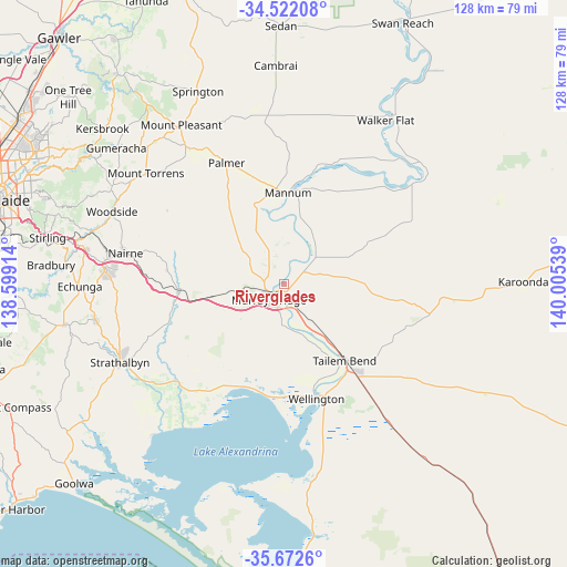
Riverglades GPS coordinates[2]
35° 5' 57.732" South, 139° 18' 8.136" East
| Map corner | latitude | longitude |
|---|---|---|
| Upper-left | -34.52208°, | 138.59914° |
| Center: | -35.09937°, | 139.30226° |
| Lower-right: | -35.6726°, | 140.00539° |
| Map W x H: | 127.9×127.9 km | = 79.5×79.5mi |
| max Lat: | -10.58257° ⇑73% North |
| Riverglades: | -35.09937° |
| min Lat: | ⇓27% South -43.31423° |
| min Long | Riverglades | max Long |
| 113.53327° | 139.30226° | 153.61246° |
| W 23.5%⇐ | ⇒76.5% E |
Elevation
Elevation of Riverglades is 14 m = 46 ft, and this is 108 m = 354 ft below average elevation for this country.
| Max E: |
1715 m = 5627 ft | 81.9% |
| Avg. | 122 m = 400 ft | |
| Riverglades | 14 m = 46 ft | |
Min E: |
-2 m = -7 ft | 18.1% |
See also: Australia elevation on elevation.city.
Geographical zone
Riverglades is located in South temperate zone (between Tropic of Capricorn and the Antarctic Circle). Distance of this Southern Tropic circle is 1296.8 km =805.8 mi to North.| Distance of | km | miles | from Riverglades |
|---|---|---|---|
| Equator | 3902.7 | 2425 | to North |
| Tropic Capricorn | 1296.8 | 805.8 | to North |
| Antarctic Circle | 3498.5 | 2173.9 | to South |
| South Pole | 6104.4 | 3793.1 | to South |


Nearby cities:
15 places around Riverglades: (largest is in red/bold)
• Callington
23.8 km =14.8 mi,  264°
264°
• Charleston
41.9 km =26 mi,  299°
299°
• Kanmantoo
26.5 km =16.5 mi,  277°
277°
• Little Hampton
40.4 km =25.1 mi, 279°
• Macclesfield
43.2 km =26.8 mi, 259°
• Mannum
20.5 km =12.7 mi,  0°
0°
• Mount Barker
39.8 km =24.7 mi, 275°
• Mount Pleasant
42.8 km =26.6 mi,  327°
327°
• Mount Torrens
40 km =24.9 mi,  308°
308°
• Murray Bridge
3.5 km =2.2 mi,  228°
228°
• Nairne
36.3 km =22.6 mi, 281°
• Oakbank
43.6 km =27.1 mi,  287°
287°
• Strathalbyn
41.3 km =25.7 mi,  244°
244°
• Tailem Bend
22 km =13.7 mi,  140°
140°
• Woodside
41.8 km =26 mi, 292°
Sources, notices
• [Note1] Compared only with cities in Australia existing in our database
• [Src1] Map data: © OpenStreetMap contributors (CC-BY-SA)
• [Src2] Other city data from geonames.org with taken over terms of usage.
• [Src3] Geographical zone / Annual Mean Temperature by Robert A. Rohde @ Wikipedia
