Margaret River geodata
Margaret River (Western Australia) is a populated place; located in Australia in Australia/Perth (GMT+8) time zone. With population of 7,571 people, there are 893 cities with bigger population in this country. Compared to other cities in Australia, 57.9% of cities are located further ↑North; 99.2% of cities are located further →East and 69.2% of cities have lower elevation than Margaret River. Note1


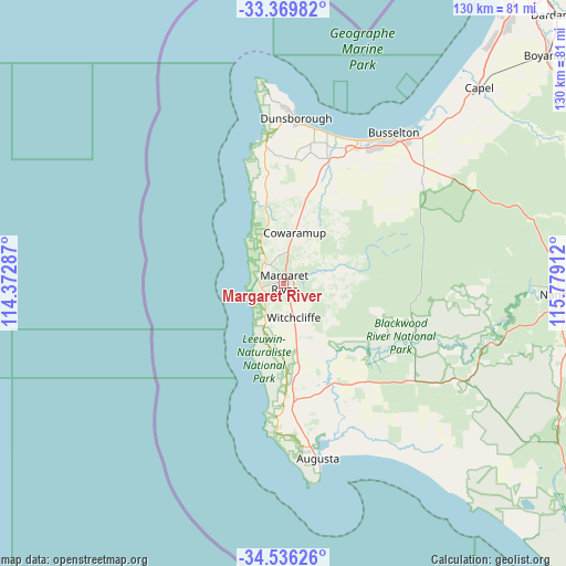
Margaret River GPS coordinates[2]
33° 57' 18.144" South, 115° 4' 33.564" East
| Map corner | latitude | longitude |
|---|---|---|
| Upper-left | -33.36982°, | 114.37287° |
| Center: | -33.95504°, | 115.07599° |
| Lower-right: | -34.53626°, | 115.77912° |
| Map W x H: | 129.7×129.7 km | = 80.6×80.6mi |
| max Lat: | -10.58257° ⇑57.9% North |
| Margaret River: | -33.95504° |
| min Lat: | ⇓42.1% South -43.31423° |
| min Long | Margaret River | max Long |
| 113.53327° | 115.07599° | 153.61246° |
| W 0.8%⇐ | ⇒99.2% E |
Elevation
Elevation of Margaret River is 98 m = 322 ft, and this is 24 m = 79 ft below average elevation for this country.
| Max E: |
1715 m = 5627 ft | 30.8% |
| Avg. | 122 m = 400 ft | |
| Margaret River | 98 m = 322 ft | |
Min E: |
-2 m = -7 ft | 69.2% |
See also: Australia elevation on elevation.city.
Geographical zone
Margaret River is located in South temperate zone (between Tropic of Capricorn and the Antarctic Circle). Distance of this Southern Tropic circle is 1169.5 km =726.7 mi to North.| Distance of | km | miles | from Margaret River |
|---|---|---|---|
| Equator | 3775.4 | 2345.9 | to North |
| Tropic Capricorn | 1169.5 | 726.7 | to North |
| Antarctic Circle | 3625.7 | 2252.9 | to South |
| South Pole | 6231.6 | 3872.1 | to South |


Nearby cities:
15 places around Margaret River: (largest is in red/bold)
• Abbey
36.4 km =22.6 mi,  27°
27°
• Augusta
40.8 km =25.4 mi,  169°
169°
• Broadwater
37.7 km =23.4 mi, 30°
• Busselton
41.9 km =26 mi,  36°
36°
• Busselton city cenre
42.2 km =26.2 mi, 36°
• Cowaramup
11.9 km =7.4 mi,  12°
12°
• Dunsborough
37.9 km =23.5 mi,  3°
3°
• Geographe
45.1 km =28 mi, 39°
• Gnarabup
8.5 km =5.3 mi,  240°
240°
• Marybrook
35.6 km =22.1 mi,  19°
19°
• Quindalup
36.2 km =22.5 mi, 10°
• Vasse
34.1 km =21.2 mi, 31°
• West Busselton
40.1 km =24.9 mi, 34°
• Yallingup
34.6 km =21.5 mi,  353°
353°
• Yalyalup
44.1 km =27.4 mi,  45°
45°
Sources, notices
• [Note1] Compared only with cities in Australia existing in our database
• [Src1] Map data: © OpenStreetMap contributors (CC-BY-SA)
• [Src2] Other city data from geonames.org with taken over terms of usage.
• [Src3] Geographical zone / Annual Mean Temperature by Robert A. Rohde @ Wikipedia
