Augusta geodata
Augusta (Western Australia) is a populated place; located in Australia in Australia/Perth (GMT+8) time zone. With population of 1,362 people, there are 3401 cities with bigger population in this country. Compared to other cities in Australia, 61.9% of cities are located further ↑North; 99.1% of cities are located further →East and 55.9% of cities have higher elevation than Augusta. Note1


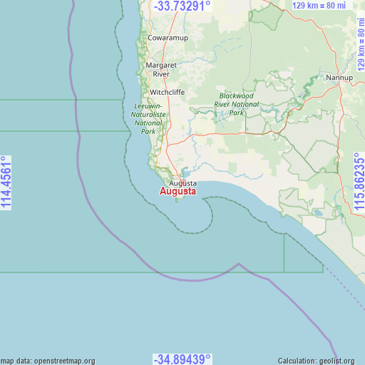
Augusta GPS coordinates[2]
34° 18' 56.376" South, 115° 9' 33.192" East
| Map corner | latitude | longitude |
|---|---|---|
| Upper-left | -33.73291°, | 114.4561° |
| Center: | -34.31566°, | 115.15922° |
| Lower-right: | -34.89439°, | 115.86235° |
| Map W x H: | 129.1×129.1 km | = 80.2×80.2mi |
| max Lat: | -10.58257° ⇑61.9% North |
| Augusta: | -34.31566° |
| min Lat: | ⇓38.1% South -43.31423° |
| min Long | Augusta | max Long |
| 113.53327° | 115.15922° | 153.61246° |
| W 0.9%⇐ | ⇒99.1% E |
Elevation
Elevation of Augusta is 37 m = 121 ft, and this is 85 m = 279 ft below average elevation for this country.
| Max E: |
1715 m = 5627 ft | 55.9% |
| Avg. | 122 m = 400 ft | |
| Augusta | 37 m = 121 ft | |
Min E: |
-2 m = -7 ft | 44.1% |
See also: Australia elevation on elevation.city.
Geographical zone
Augusta is located in South temperate zone (between Tropic of Capricorn and the Antarctic Circle). Distance of this Southern Tropic circle is 1209.6 km =751.6 mi to North.| Distance of | km | miles | from Augusta |
|---|---|---|---|
| Equator | 3815.5 | 2370.8 | to North |
| Tropic Capricorn | 1209.6 | 751.6 | to North |
| Antarctic Circle | 3585.6 | 2228 | to South |
| South Pole | 6191.5 | 3847.2 | to South |


Nearby cities:
15 places around Augusta: (largest is in red/bold)
• Abbey
73 km =45.4 mi,  7°
7°
• Broadwater
73.5 km =45.7 mi, 9°
• Busselton
75.7 km =47 mi, 13°
• Busselton city cenre
76 km =47.2 mi, 13°
• Cowaramup
52 km =32.3 mi,  354°
354°
• Geographe
78 km =48.5 mi,  15°
15°
• Gnarabup
38.9 km =24.2 mi,  337°
337°
• Margaret River
40.8 km =25.4 mi, 349°
• Marybrook
73.8 km =45.9 mi,  3°
3°
• Nannup
67.1 km =41.7 mi,  56°
56°
• Quindalup
75.6 km =47 mi,  359°
359°
• Vasse
69.9 km =43.4 mi, 8°
• West Busselton
74.7 km =46.4 mi, 11°
• Yallingup
75.3 km =46.8 mi, 351°
• Yalyalup
75 km =46.6 mi, 18°
Sources, notices
• [Note1] Compared only with cities in Australia existing in our database
• [Src1] Map data: © OpenStreetMap contributors (CC-BY-SA)
• [Src2] Other city data from geonames.org with taken over terms of usage.
• [Src3] Geographical zone / Annual Mean Temperature by Robert A. Rohde @ Wikipedia
