Lyndoch geodata
Lyndoch (South Australia) is a populated place; located in Australia in Australia/Adelaide (GMT+10.5) time zone. With population of 1,966 people, there are 2933 cities with bigger population in this country. Compared to other cities in Australia, 64.1% of cities are located further ↑North; 77% of cities are located further →East and 79.8% of cities have lower elevation than Lyndoch. Note1


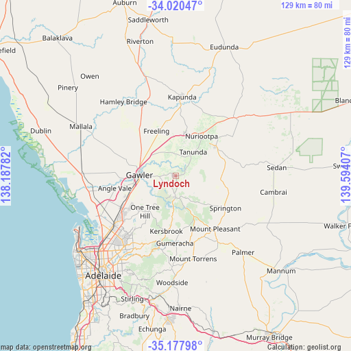
Lyndoch GPS coordinates[2]
34° 36' 4.464" South, 138° 53' 27.384" East
| Map corner | latitude | longitude |
|---|---|---|
| Upper-left | -34.02047°, | 138.18782° |
| Center: | -34.60124°, | 138.89094° |
| Lower-right: | -35.17798°, | 139.59407° |
| Map W x H: | 128.7×128.7 km | = 80×80mi |
| max Lat: | -10.58257° ⇑64.1% North |
| Lyndoch: | -34.60124° |
| min Lat: | ⇓35.9% South -43.31423° |
| min Long | Lyndoch | max Long |
| 113.53327° | 138.89094° | 153.61246° |
| W 23%⇐ | ⇒77% E |
Elevation
Elevation of Lyndoch is 178 m = 584 ft, and this is 56 m = 184 ft above average elevation for this country.
| Max E: |
1715 m = 5627 ft | 20.2% |
| Lyndoch | 178 m 584 ft | |
| Avg. | 122 m = 400 ft | |
Min E: |
-2 m = -7 ft | 79.8% |
See also: Australia elevation on elevation.city.
Geographical zone
Lyndoch is located in South temperate zone (between Tropic of Capricorn and the Antarctic Circle). Distance of this Southern Tropic circle is 1241.4 km =771.4 mi to North.| Distance of | km | miles | from Lyndoch |
|---|---|---|---|
| Equator | 3847.3 | 2390.6 | to North |
| Tropic Capricorn | 1241.4 | 771.4 | to North |
| Antarctic Circle | 3553.9 | 2208.3 | to South |
| South Pole | 6159.8 | 3827.5 | to South |


Nearby cities:
15 places around Lyndoch: (largest is in red/bold)
• Cockatoo Valley
5.6 km =3.5 mi,  242°
242°
• Evanston
14.5 km =9 mi,  263°
263°
• Evanston Gardens
15.7 km =9.8 mi, 261°
• Evanston Park
13.9 km =8.6 mi, 260°
• Gawler
13 km =8.1 mi,  269°
269°
• Gawler East
11.7 km =7.3 mi, 271°
• Gawler South
13.4 km =8.3 mi, 267°
• Gawler West
14.5 km =9 mi, 268°
• Gawler city centre
13.5 km =8.4 mi, 272°
• Hewett
12.9 km =8 mi,  281°
281°
• One Tree Hill
15.8 km =9.8 mi,  225°
225°
• Roseworthy
14.9 km =9.3 mi,  300°
300°
• Tanunda
10.7 km =6.6 mi,  36°
36°
• Willaston
13.8 km =8.6 mi, 276°
• Williamstown
7.9 km =4.9 mi,  179°
179°
Sources, notices
• [Note1] Compared only with cities in Australia existing in our database
• [Src1] Map data: © OpenStreetMap contributors (CC-BY-SA)
• [Src2] Other city data from geonames.org with taken over terms of usage.
• [Src3] Geographical zone / Annual Mean Temperature by Robert A. Rohde @ Wikipedia
