Roseworthy geodata
Roseworthy (South Australia) is a populated place; located in Australia in Australia/Adelaide (GMT+10.5) time zone. With population of 965 people, there are 3873 cities with bigger population in this country. Compared to other cities in Australia, 63.5% of cities are located further ↑North; 77.5% of cities are located further →East and 74% of cities have lower elevation than Roseworthy. Note1


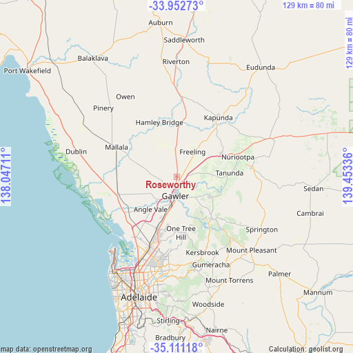
Roseworthy GPS coordinates[2]
34° 32' 2.292" South, 138° 45' 0.828" East
| Map corner | latitude | longitude |
|---|---|---|
| Upper-left | -33.95273°, | 138.04711° |
| Center: | -34.53397°, | 138.75023° |
| Lower-right: | -35.11118°, | 139.45336° |
| Map W x H: | 128.8×128.8 km | = 80×80mi |
| max Lat: | -10.58257° ⇑63.5% North |
| Roseworthy: | -34.53397° |
| min Lat: | ⇓36.5% South -43.31423° |
| min Long | Roseworthy | max Long |
| 113.53327° | 138.75023° | 153.61246° |
| W 22.5%⇐ | ⇒77.5% E |
Elevation
Elevation of Roseworthy is 123 m = 404 ft, and this is 1 m = 3 ft above average elevation for this country.
| Max E: |
1715 m = 5627 ft | 26% |
| Roseworthy | 123 m 404 ft | |
| Avg. | 122 m = 400 ft | |
Min E: |
-2 m = -7 ft | 74% |
See also: Australia elevation on elevation.city.
Geographical zone
Roseworthy is located in South temperate zone (between Tropic of Capricorn and the Antarctic Circle). Distance of this Southern Tropic circle is 1233.9 km =766.7 mi to North.| Distance of | km | miles | from Roseworthy |
|---|---|---|---|
| Equator | 3839.8 | 2385.9 | to North |
| Tropic Capricorn | 1233.9 | 766.7 | to North |
| Antarctic Circle | 3561.4 | 2213 | to South |
| South Pole | 6167.2 | 3832.1 | to South |


Nearby cities:
15 places around Roseworthy: (largest is in red/bold)
• Cockatoo Valley
12.8 km =8 mi,  141°
141°
• Evanston
9.3 km =5.8 mi,  189°
189°
• Evanston Gardens
10.3 km =6.4 mi, 194°
• Evanston Park
9.9 km =6.2 mi,  184°
184°
• Freeling
10.4 km =6.5 mi,  31°
31°
• Gawler
7.6 km =4.7 mi, 180°
• Gawler East
7.3 km =4.5 mi,  170°
170°
• Gawler South
8.2 km =5.1 mi, 183°
• Gawler West
8 km =5 mi, 191°
• Gawler city centre
7 km =4.3 mi, 184°
• Hewett
4.9 km =3 mi, 177°
• Hillier
13.1 km =8.1 mi,  214°
214°
• Kudla
12.8 km =8 mi,  200°
200°
• Wasleys
9.3 km =5.8 mi,  320°
320°
• Willaston
5.9 km =3.7 mi, 188°
Sources, notices
• [Note1] Compared only with cities in Australia existing in our database
• [Src1] Map data: © OpenStreetMap contributors (CC-BY-SA)
• [Src2] Other city data from geonames.org with taken over terms of usage.
• [Src3] Geographical zone / Annual Mean Temperature by Robert A. Rohde @ Wikipedia
