Lobethal geodata
Lobethal (South Australia) is a populated place; located in Australia in Australia/Adelaide (GMT+10.5) time zone. With population of 2,474 people, there are 2591 cities with bigger population in this country. Compared to other cities in Australia, 68.3% of cities are located further ↑North; 77% of cities are located further →East and 91.3% of cities have lower elevation than Lobethal. Note1


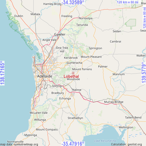
Lobethal GPS coordinates[2]
34° 54' 16.38" South, 138° 52' 29.172" East
| Map corner | latitude | longitude |
|---|---|---|
| Upper-left | -34.32589°, | 138.17165° |
| Center: | -34.90455°, | 138.87477° |
| Lower-right: | -35.47916°, | 139.5779° |
| Map W x H: | 128.2×128.2 km | = 79.7×79.7mi |
| max Lat: | -10.58257° ⇑68.3% North |
| Lobethal: | -34.90455° |
| min Lat: | ⇓31.7% South -43.31423° |
| min Long | Lobethal | max Long |
| 113.53327° | 138.87477° | 153.61246° |
| W 23%⇐ | ⇒77% E |
Elevation
Elevation of Lobethal is 422 m = 1385 ft, and this is 300 m = 984 ft above average elevation for this country.
| Max E: |
1715 m = 5627 ft | 8.7% |
| Lobethal | 422 m 1385 ft | |
| Avg. | 122 m = 400 ft | |
Min E: |
-2 m = -7 ft | 91.3% |
See also: Australia elevation on elevation.city.
Geographical zone
Lobethal is located in South temperate zone (between Tropic of Capricorn and the Antarctic Circle). Distance of this Southern Tropic circle is 1275.1 km =792.3 mi to North.| Distance of | km | miles | from Lobethal |
|---|---|---|---|
| Equator | 3881 | 2411.5 | to North |
| Tropic Capricorn | 1275.1 | 792.3 | to North |
| Antarctic Circle | 3520.2 | 2187.4 | to South |
| South Pole | 6126 | 3806.5 | to South |


Nearby cities:
15 places around Lobethal: (largest is in red/bold)
• Adelaide Hills
15.3 km =9.5 mi,  267°
267°
• Balhannah
10.6 km =6.6 mi,  204°
204°
• Birdwood
12.6 km =7.8 mi,  40°
40°
• Charleston
2.7 km =1.7 mi,  120°
120°
• Gumeracha
9 km =5.6 mi,  5°
5°
• Hahndorf
15.1 km =9.4 mi, 203°
• Kersbrook
13.7 km =8.5 mi,  350°
350°
• Little Hampton
15.3 km =9.5 mi,  183°
183°
• Mount Torrens
8.3 km =5.2 mi,  67°
67°
• Nairne
14.8 km =9.2 mi,  166°
166°
• Norton Summit
13.8 km =8.6 mi,  261°
261°
• Oakbank
9.2 km =5.7 mi, 197°
• Summertown
14.4 km =8.9 mi,  244°
244°
• Uraidla
13.2 km =8.2 mi, 244°
• Woodside
5.5 km =3.4 mi, 176°
Sources, notices
• [Note1] Compared only with cities in Australia existing in our database
• [Src1] Map data: © OpenStreetMap contributors (CC-BY-SA)
• [Src2] Other city data from geonames.org with taken over terms of usage.
• [Src3] Geographical zone / Annual Mean Temperature by Robert A. Rohde @ Wikipedia
