Kersbrook geodata
Kersbrook (South Australia) is a populated place; located in Australia in Australia/Adelaide (GMT+10.5) time zone. With population of 1,040 people, there are 3767 cities with bigger population in this country. Compared to other cities in Australia, 65.6% of cities are located further ↑North; 77.1% of cities are located further →East and 89.2% of cities have lower elevation than Kersbrook. Note1


Kersbrook GPS coordinates[2]
34° 46' 58.98" South, 138° 51' 3.276" East
| Map corner | latitude | longitude |
|---|---|---|
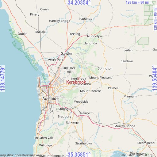
| Upper-left | -34.20354°, | 138.14779° |
| Center: | -34.78305°, | 138.85091° |
| Lower-right: | -35.35851°, | 139.55404° |
| Map W x H: | 128.4×128.4 km | = 79.8×79.8mi |
| max Lat: | -10.58257° ⇑65.6% North |
| Kersbrook: | -34.78305° |
| min Lat: | ⇓34.4% South -43.31423° |
| min Long | Kersbrook | max Long |
| 113.53327° | 138.85091° | 153.61246° |
| W 22.9%⇐ | ⇒77.1% E |
Elevation
Elevation of Kersbrook is 353 m = 1158 ft, and this is 231 m = 758 ft above average elevation for this country.
| Max E: |
1715 m = 5627 ft | 10.8% |
| Kersbrook | 353 m 1158 ft | |
| Avg. | 122 m = 400 ft | |
Min E: |
-2 m = -7 ft | 89.2% |
See also: Australia elevation on elevation.city.
Geographical zone
Kersbrook is located in South temperate zone (between Tropic of Capricorn and the Antarctic Circle). Distance of this Southern Tropic circle is 1261.6 km =783.9 mi to North.| Distance of | km | miles | from Kersbrook |
|---|---|---|---|
| Equator | 3867.5 | 2403.2 | to North |
| Tropic Capricorn | 1261.6 | 783.9 | to North |
| Antarctic Circle | 3533.7 | 2195.7 | to South |
| South Pole | 6139.5 | 3814.9 | to South |


Nearby cities:
15 places around Kersbrook: (largest is in red/bold)
• Banksia Park
10.9 km =6.8 mi,  254°
254°
• Birdwood
11.1 km =6.9 mi,  110°
110°
• Fairview Park
11.3 km =7 mi,  260°
260°
• Golden Grove
10.7 km =6.6 mi,  269°
269°
• Greenwith
12.7 km =7.9 mi,  278°
278°
• Gumeracha
5.5 km =3.4 mi,  145°
145°
• Lobethal
13.7 km =8.5 mi,  170°
170°
• One Tree Hill
12 km =7.5 mi,  320°
320°
• Redwood Park
13.5 km =8.4 mi, 256°
• Ridgehaven
14 km =8.7 mi, 252°
• St Agnes
13.9 km =8.6 mi, 247°
• Surrey Downs
12.9 km =8 mi, 261°
• Tea Tree Gully
11.4 km =7.1 mi, 250°
• Vista
13 km =8.1 mi,  243°
243°
• Williamstown
12.9 km =8 mi,  16°
16°
Sources, notices
• [Note1] Compared only with cities in Australia existing in our database
• [Src1] Map data: © OpenStreetMap contributors (CC-BY-SA)
• [Src2] Other city data from geonames.org with taken over terms of usage.
• [Src3] Geographical zone / Annual Mean Temperature by Robert A. Rohde @ Wikipedia
