Kenwick geodata
Kenwick (Western Australia) is a section of populated place; located in Australia in Australia/Perth (GMT+8) time zone. With population of 5,648 people, there are 1299 cities with bigger population in this country. Compared to other cities in Australia, 64.5% of cities are located further ↓South; 93% of cities are located further →East and 86.8% of cities have higher elevation than Kenwick. Note1


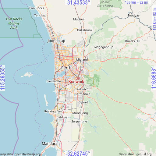
Kenwick GPS coordinates[2]
32° 1' 59.988" South, 115° 58' 0.012" East
| Map corner | latitude | longitude |
|---|---|---|
| Upper-left | -31.43533°, | 115.26355° |
| Center: | -32.03333°, | 115.96667° |
| Lower-right: | -32.62745°, | 116.6698° |
| Map W x H: | 132.6×132.6 km | = 82.4×82.4mi |
| max Lat: | -10.58257° ⇑35.5% North |
| Kenwick: | -32.03333° |
| min Lat: | ⇓64.5% South -43.31423° |
| min Long | Kenwick | max Long |
| 113.53327° | 115.96667° | 153.61246° |
| W 7%⇐ | ⇒93% E |
Elevation
Elevation of Kenwick is 11 m = 36 ft, and this is 111 m = 364 ft below average elevation for this country.
| Max E: |
1715 m = 5627 ft | 86.8% |
| Avg. | 122 m = 400 ft | |
| Kenwick | 11 m = 36 ft | |
Min E: |
-2 m = -7 ft | 13.2% |
See also: Australia elevation on elevation.city.
Geographical zone
Kenwick is located in South temperate zone (between Tropic of Capricorn and the Antarctic Circle). Distance of this Southern Tropic circle is 955.9 km =594 mi to North.| Distance of | km | miles | from Kenwick |
|---|---|---|---|
| Equator | 3561.8 | 2213.2 | to North |
| Tropic Capricorn | 955.9 | 594 | to North |
| Antarctic Circle | 3839.4 | 2385.7 | to South |
| South Pole | 6445.3 | 4004.9 | to South |


Nearby cities:
15 places around Kenwick: (largest is in red/bold)
• Beckenham
1.1 km =0.7 mi,  325°
325°
• Bentley
5.3 km =3.3 mi,  311°
311°
• Canning Vale
5.3 km =3.3 mi,  239°
239°
• Cannington
3.4 km =2.1 mi,  303°
303°
• East Cannington
2.8 km =1.7 mi,  337°
337°
• Ferndale
4.2 km =2.6 mi,  267°
267°
• Langford
2.5 km =1.6 mi,  250°
250°
• Lynwood
3.6 km =2.2 mi,  258°
258°
• Maddington
2.4 km =1.5 mi,  139°
139°
• Orange Grove
3.7 km =2.3 mi,  83°
83°
• Parkwood
4.9 km =3 mi, 248°
• Queens Park
3.9 km =2.4 mi, 330°
• Thornlie
3.2 km =2 mi,  200°
200°
• Wattle Grove
4.3 km =2.7 mi,  47°
47°
• Wilson
5.4 km =3.4 mi,  285°
285°
Sources, notices
• [Note1] Compared only with cities in Australia existing in our database
• [Src1] Map data: © OpenStreetMap contributors (CC-BY-SA)
• [Src2] Other city data from geonames.org with taken over terms of usage.
• [Src3] Geographical zone / Annual Mean Temperature by Robert A. Rohde @ Wikipedia
