Bentley geodata
Bentley (Western Australia) is a populated place; located in Australia in Australia/Perth (GMT+8) time zone. With population of 8,323 people, there are 783 cities with bigger population in this country. Compared to other cities in Australia, 65.1% of cities are located further ↓South; 93.5% of cities are located further →East and 73.6% of cities have higher elevation than Bentley. Note1


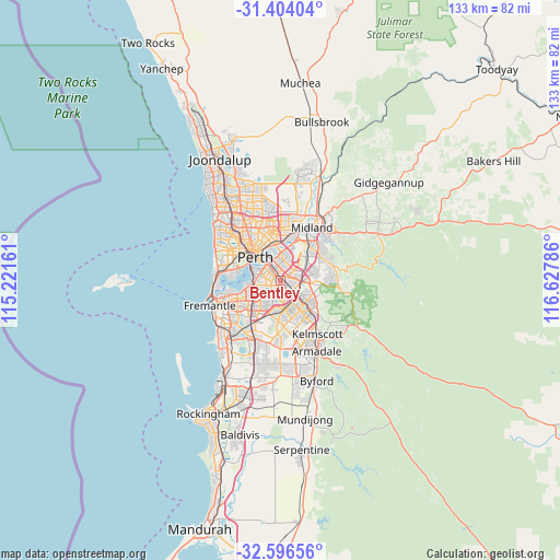
Bentley GPS coordinates[2]
32° 0' 8.064" South, 115° 55' 29.028" East
| Map corner | latitude | longitude |
|---|---|---|
| Upper-left | -31.40404°, | 115.22161° |
| Center: | -32.00224°, | 115.92473° |
| Lower-right: | -32.59656°, | 116.62786° |
| Map W x H: | 132.6×132.6 km | = 82.4×82.4mi |
| max Lat: | -10.58257° ⇑34.9% North |
| Bentley: | -32.00224° |
| min Lat: | ⇓65.1% South -43.31423° |
| min Long | Bentley | max Long |
| 113.53327° | 115.92473° | 153.61246° |
| W 6.5%⇐ | ⇒93.5% E |
Elevation
Elevation of Bentley is 20 m = 66 ft, and this is 102 m = 335 ft below average elevation for this country.
| Max E: |
1715 m = 5627 ft | 73.6% |
| Avg. | 122 m = 400 ft | |
| Bentley | 20 m = 66 ft | |
Min E: |
-2 m = -7 ft | 26.4% |
See also: Australia elevation on elevation.city.
Geographical zone
Bentley is located in South temperate zone (between Tropic of Capricorn and the Antarctic Circle). Distance of this Southern Tropic circle is 952.4 km =591.8 mi to North.| Distance of | km | miles | from Bentley |
|---|---|---|---|
| Equator | 3558.3 | 2211 | to North |
| Tropic Capricorn | 952.4 | 591.8 | to North |
| Antarctic Circle | 3842.9 | 2387.9 | to South |
| South Pole | 6448.7 | 4007 | to South |


Nearby cities:
15 places around Bentley: (largest is in red/bold)
• Beckenham
4.2 km =2.6 mi,  127°
127°
• Cannington
1.9 km =1.2 mi,  144°
144°
• Carlisle
2.6 km =1.6 mi,  346°
346°
• East Cannington
3 km =1.9 mi,  106°
106°
• East Victoria Park
2.5 km =1.6 mi,  306°
306°
• Ferndale
3.6 km =2.2 mi,  183°
183°
• Karawara
4.2 km =2.6 mi,  260°
260°
• Kewdale
3.6 km =2.2 mi,  44°
44°
• Lathlain
4.2 km =2.6 mi,  335°
335°
• Lynwood
4.2 km =2.6 mi,  174°
174°
• Queens Park
2 km =1.2 mi,  92°
92°
• St James
1.4 km =0.9 mi,  279°
279°
• Victoria Park
3.4 km =2.1 mi,  327°
327°
• Waterford
3.9 km =2.4 mi,  247°
247°
• Wilson
2.4 km =1.5 mi,  210°
210°
Sources, notices
• [Note1] Compared only with cities in Australia existing in our database
• [Src1] Map data: © OpenStreetMap contributors (CC-BY-SA)
• [Src2] Other city data from geonames.org with taken over terms of usage.
• [Src3] Geographical zone / Annual Mean Temperature by Robert A. Rohde @ Wikipedia
