Beckenham geodata
Beckenham (Western Australia) is a section of populated place; located in Australia in Australia/Perth (GMT+8) time zone. With population of 7,385 people, there are 916 cities with bigger population in this country. Compared to other cities in Australia, 64.7% of cities are located further ↓South; 93% of cities are located further →East and 86.8% of cities have higher elevation than Beckenham. Note1


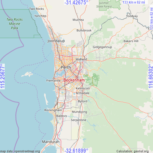
Beckenham GPS coordinates[2]
32° 1' 29.316" South, 115° 57' 35.604" East
| Map corner | latitude | longitude |
|---|---|---|
| Upper-left | -31.42675°, | 115.25677° |
| Center: | -32.02481°, | 115.95989° |
| Lower-right: | -32.61899°, | 116.66302° |
| Map W x H: | 132.6×132.6 km | = 82.4×82.4mi |
| max Lat: | -10.58257° ⇑35.3% North |
| Beckenham: | -32.02481° |
| min Lat: | ⇓64.7% South -43.31423° |
| min Long | Beckenham | max Long |
| 113.53327° | 115.95989° | 153.61246° |
| W 7%⇐ | ⇒93% E |
Elevation
Elevation of Beckenham is 11 m = 36 ft, and this is 111 m = 364 ft below average elevation for this country.
| Max E: |
1715 m = 5627 ft | 86.8% |
| Avg. | 122 m = 400 ft | |
| Beckenham | 11 m = 36 ft | |
Min E: |
-2 m = -7 ft | 13.2% |
See also: Australia elevation on elevation.city.
Geographical zone
Beckenham is located in South temperate zone (between Tropic of Capricorn and the Antarctic Circle). Distance of this Southern Tropic circle is 954.9 km =593.3 mi to North.| Distance of | km | miles | from Beckenham |
|---|---|---|---|
| Equator | 3560.8 | 2212.6 | to North |
| Tropic Capricorn | 954.9 | 593.3 | to North |
| Antarctic Circle | 3840.3 | 2386.3 | to South |
| South Pole | 6446.2 | 4005.5 | to South |


Nearby cities:
15 places around Beckenham: (largest is in red/bold)
• Bentley
4.2 km =2.6 mi,  307°
307°
• Cannington
2.4 km =1.5 mi,  293°
293°
• East Cannington
1.7 km =1.1 mi,  344°
344°
• Ferndale
3.7 km =2.3 mi,  252°
252°
• Kenwick
1.1 km =0.7 mi,  145°
145°
• Kewdale
5.2 km =3.2 mi,  351°
351°
• Langford
2.5 km =1.6 mi,  223°
223°
• Lynwood
3.4 km =2.1 mi,  239°
239°
• Maddington
3.6 km =2.2 mi,  141°
141°
• Orange Grove
4.3 km =2.7 mi,  96°
96°
• Parkwood
4.8 km =3 mi, 235°
• Queens Park
2.7 km =1.7 mi,  331°
331°
• Thornlie
3.9 km =2.4 mi,  186°
186°
• Wattle Grove
4.3 km =2.7 mi,  62°
62°
• Wilson
4.6 km =2.9 mi,  275°
275°
Sources, notices
• [Note1] Compared only with cities in Australia existing in our database
• [Src1] Map data: © OpenStreetMap contributors (CC-BY-SA)
• [Src2] Other city data from geonames.org with taken over terms of usage.
• [Src3] Geographical zone / Annual Mean Temperature by Robert A. Rohde @ Wikipedia
