Parkwood geodata
Parkwood (Western Australia) is a section of populated place; located in Australia in Australia/Perth (GMT+8) time zone. With population of 5,877 people, there are 1236 cities with bigger population in this country. Compared to other cities in Australia, 64.2% of cities are located further ↓South; 93.5% of cities are located further →East and 81.9% of cities have higher elevation than Parkwood. Note1


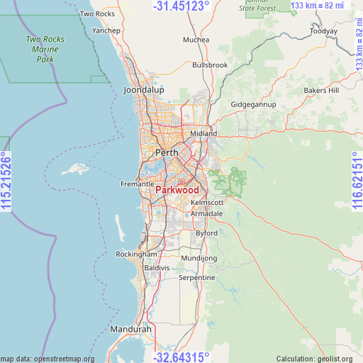
Parkwood GPS coordinates[2]
32° 2' 56.868" South, 115° 55' 6.168" East
| Map corner | latitude | longitude |
|---|---|---|
| Upper-left | -31.45123°, | 115.21526° |
| Center: | -32.04913°, | 115.91838° |
| Lower-right: | -32.64315°, | 116.62151° |
| Map W x H: | 132.5×132.5 km | = 82.3×82.3mi |
| max Lat: | -10.58257° ⇑35.8% North |
| Parkwood: | -32.04913° |
| min Lat: | ⇓64.2% South -43.31423° |
| min Long | Parkwood | max Long |
| 113.53327° | 115.91838° | 153.61246° |
| W 6.5%⇐ | ⇒93.5% E |
Elevation
Elevation of Parkwood is 14 m = 46 ft, and this is 108 m = 354 ft below average elevation for this country.
| Max E: |
1715 m = 5627 ft | 81.9% |
| Avg. | 122 m = 400 ft | |
| Parkwood | 14 m = 46 ft | |
Min E: |
-2 m = -7 ft | 18.1% |
See also: Australia elevation on elevation.city.
Geographical zone
Parkwood is located in South temperate zone (between Tropic of Capricorn and the Antarctic Circle). Distance of this Southern Tropic circle is 957.6 km =595 mi to North.| Distance of | km | miles | from Parkwood |
|---|---|---|---|
| Equator | 3563.5 | 2214.3 | to North |
| Tropic Capricorn | 957.6 | 595 | to North |
| Antarctic Circle | 3837.6 | 2384.6 | to South |
| South Pole | 6443.5 | 4003.8 | to South |


Nearby cities:
15 places around Parkwood: (largest is in red/bold)
• Beckenham
4.8 km =3 mi,  55°
55°
• Bentley
5.2 km =3.2 mi,  6°
6°
• Canning Vale
1 km =0.6 mi,  181°
181°
• Cannington
4 km =2.5 mi,  25°
25°
• Ferndale
1.6 km =1 mi, 13°
• Kenwick
4.9 km =3 mi,  68°
68°
• Langford
2.4 km =1.5 mi, 67°
• Lynwood
1.4 km =0.9 mi,  44°
44°
• Riverton
2.5 km =1.6 mi,  310°
310°
• Rossmoyne
4.9 km =3 mi,  282°
282°
• Shelley
3.7 km =2.3 mi, 306°
• Thornlie
3.7 km =2.3 mi,  109°
109°
• Waterford
4.8 km =3 mi,  321°
321°
• Willetton
2.9 km =1.8 mi,  262°
262°
• Wilson
3.2 km =2 mi,  348°
348°
Sources, notices
• [Note1] Compared only with cities in Australia existing in our database
• [Src1] Map data: © OpenStreetMap contributors (CC-BY-SA)
• [Src2] Other city data from geonames.org with taken over terms of usage.
• [Src3] Geographical zone / Annual Mean Temperature by Robert A. Rohde @ Wikipedia
