Kendenup geodata
Kendenup (Western Australia) is a populated place; located in Australia in Australia/Perth (GMT+8) time zone. With population of 949 people, there are 3898 cities with bigger population in this country. Compared to other cities in Australia, 63.1% of cities are located further ↑North; 90.3% of cities are located further →East and 85.8% of cities have lower elevation than Kendenup. Note1


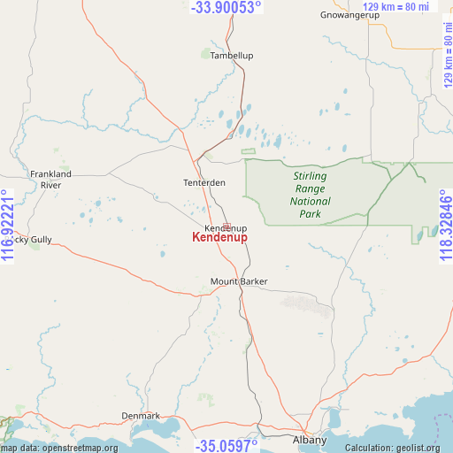
Kendenup GPS coordinates[2]
34° 28' 55.668" South, 117° 37' 31.188" East
| Map corner | latitude | longitude |
|---|---|---|
| Upper-left | -33.90053°, | 116.92221° |
| Center: | -34.48213°, | 117.62533° |
| Lower-right: | -35.0597°, | 118.32846° |
| Map W x H: | 128.9×128.9 km | = 80.1×80.1mi |
| max Lat: | -10.58257° ⇑63.1% North |
| Kendenup: | -34.48213° |
| min Lat: | ⇓36.9% South -43.31423° |
| min Long | Kendenup | max Long |
| 113.53327° | 117.62533° | 153.61246° |
| W 9.7%⇐ | ⇒90.3% E |
Elevation
Elevation of Kendenup is 262 m = 860 ft, and this is 140 m = 459 ft above average elevation for this country.
| Max E: |
1715 m = 5627 ft | 14.2% |
| Kendenup | 262 m 860 ft | |
| Avg. | 122 m = 400 ft | |
Min E: |
-2 m = -7 ft | 85.8% |
See also: Australia elevation on elevation.city.
Geographical zone
Kendenup is located in South temperate zone (between Tropic of Capricorn and the Antarctic Circle). Distance of this Southern Tropic circle is 1228.1 km =763.1 mi to North.| Distance of | km | miles | from Kendenup |
|---|---|---|---|
| Equator | 3834.1 | 2382.4 | to North |
| Tropic Capricorn | 1228.1 | 763.1 | to North |
| Antarctic Circle | 3567.1 | 2216.5 | to South |
| South Pole | 6173 | 3835.7 | to South |


Nearby cities:
15 places around Kendenup: (largest is in red/bold)
• Bayonet Head
61.5 km =38.2 mi,  152°
152°
• Denmark
58.7 km =36.5 mi,  205°
205°
• Gledhow
61.1 km =38 mi,  162°
162°
• Grasmere
60.8 km =37.8 mi,  168°
168°
• Kalgan
57.1 km =35.5 mi,  141°
141°
• Lockyer
62 km =38.5 mi, 159°
• Lower King
60.1 km =37.3 mi, 151°
• McKail
59 km =36.7 mi, 161°
• Milpara
60.2 km =37.4 mi, 158°
• Mount Barker
17 km =10.6 mi, 167°
• Orana
61 km =37.9 mi, 159°
• Warrenup
58.5 km =36.4 mi, 159°
• Willyung
56.3 km =35 mi, 155°
• Yakamia
62.5 km =38.8 mi, 158°
• Youngs
60.3 km =37.5 mi,  189°
189°
Sources, notices
• [Note1] Compared only with cities in Australia existing in our database
• [Src1] Map data: © OpenStreetMap contributors (CC-BY-SA)
• [Src2] Other city data from geonames.org with taken over terms of usage.
• [Src3] Geographical zone / Annual Mean Temperature by Robert A. Rohde @ Wikipedia
