Waterford geodata
Waterford (Western Australia) is a section of populated place; located in Australia in Australia/Perth (GMT+8) time zone. With population of 2,263 people, there are 2720 cities with bigger population in this country. Compared to other cities in Australia, 64.9% of cities are located further ↓South; 94% of cities are located further →East and 93.8% of cities have higher elevation than Waterford. Note1


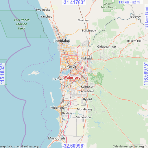
Waterford GPS coordinates[2]
32° 0' 56.664" South, 115° 53' 11.832" East
| Map corner | latitude | longitude |
|---|---|---|
| Upper-left | -31.41763°, | 115.1835° |
| Center: | -32.01574°, | 115.88662° |
| Lower-right: | -32.60998°, | 116.58975° |
| Map W x H: | 132.6×132.6 km | = 82.4×82.4mi |
| max Lat: | -10.58257° ⇑35.1% North |
| Waterford: | -32.01574° |
| min Lat: | ⇓64.9% South -43.31423° |
| min Long | Waterford | max Long |
| 113.53327° | 115.88662° | 153.61246° |
| W 6%⇐ | ⇒94% E |
Elevation
Elevation of Waterford is 7 m = 23 ft, and this is 115 m = 377 ft below average elevation for this country.
| Max E: |
1715 m = 5627 ft | 93.8% |
| Avg. | 122 m = 400 ft | |
| Waterford | 7 m = 23 ft | |
Min E: |
-2 m = -7 ft | 6.2% |
See also: Australia elevation on elevation.city.
Geographical zone
Waterford is located in South temperate zone (between Tropic of Capricorn and the Antarctic Circle). Distance of this Southern Tropic circle is 953.9 km =592.7 mi to North.| Distance of | km | miles | from Waterford |
|---|---|---|---|
| Equator | 3559.8 | 2212 | to North |
| Tropic Capricorn | 953.9 | 592.7 | to North |
| Antarctic Circle | 3841.4 | 2386.9 | to South |
| South Pole | 6447.2 | 4006.1 | to South |


Nearby cities:
15 places around Waterford: (largest is in red/bold)
• Bentley
3.9 km =2.4 mi,  67°
67°
• Como
3.5 km =2.2 mi,  321°
321°
• East Victoria Park
3.4 km =2.1 mi,  28°
28°
• Ferndale
4 km =2.5 mi,  122°
122°
• Karawara
0.9 km =0.6 mi,  326°
326°
• Manning
1.8 km =1.1 mi,  269°
269°
• Mount Pleasant
4.4 km =2.7 mi,  232°
232°
• Riverton
2.4 km =1.5 mi,  151°
151°
• Rossmoyne
3.2 km =2 mi,  213°
213°
• Salter Point
2.2 km =1.4 mi,  245°
245°
• Shelley
1.5 km =0.9 mi,  179°
179°
• South Perth
4.1 km =2.5 mi, 332°
• St James
2.8 km =1.7 mi,  51°
51°
• Willetton
4.1 km =2.5 mi, 178°
• Wilson
2.4 km =1.5 mi,  102°
102°
Sources, notices
• [Note1] Compared only with cities in Australia existing in our database
• [Src1] Map data: © OpenStreetMap contributors (CC-BY-SA)
• [Src2] Other city data from geonames.org with taken over terms of usage.
• [Src3] Geographical zone / Annual Mean Temperature by Robert A. Rohde @ Wikipedia
