Lathlain geodata
Lathlain (Western Australia) is a section of populated place; located in Australia in Australia/Perth (GMT+8) time zone. With population of 3,287 people, there are 2073 cities with bigger population in this country. Compared to other cities in Australia, 65.5% of cities are located further ↓South; 93.8% of cities are located further →East and 70.9% of cities have higher elevation than Lathlain. Note1


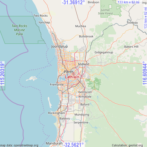
Lathlain GPS coordinates[2]
31° 58' 3.18" South, 115° 54' 22.716" East
| Map corner | latitude | longitude |
|---|---|---|
| Upper-left | -31.36912°, | 115.20319° |
| Center: | -31.96755°, | 115.90631° |
| Lower-right: | -32.5621°, | 116.60944° |
| Map W x H: | 132.6×132.6 km | = 82.4×82.4mi |
| max Lat: | -10.58257° ⇑34.5% North |
| Lathlain: | -31.96755° |
| min Lat: | ⇓65.5% South -43.31423° |
| min Long | Lathlain | max Long |
| 113.53327° | 115.90631° | 153.61246° |
| W 6.2%⇐ | ⇒93.8% E |
Elevation
Elevation of Lathlain is 22 m = 72 ft, and this is 100 m = 328 ft below average elevation for this country.
| Max E: |
1715 m = 5627 ft | 70.9% |
| Avg. | 122 m = 400 ft | |
| Lathlain | 22 m = 72 ft | |
Min E: |
-2 m = -7 ft | 29.1% |
See also: Australia elevation on elevation.city.
Geographical zone
Lathlain is located in South temperate zone (between Tropic of Capricorn and the Antarctic Circle). Distance of this Southern Tropic circle is 948.5 km =589.4 mi to North.| Distance of | km | miles | from Lathlain |
|---|---|---|---|
| Equator | 3554.5 | 2208.7 | to North |
| Tropic Capricorn | 948.5 | 589.4 | to North |
| Antarctic Circle | 3846.7 | 2390.2 | to South |
| South Pole | 6452.6 | 4009.5 | to South |


Nearby cities:
15 places around Lathlain: (largest is in red/bold)
• Ascot
3.6 km =2.2 mi,  25°
25°
• Belmont
3.2 km =2 mi, 34°
• Bentley
4.2 km =2.6 mi,  155°
155°
• Burswood
1 km =0.6 mi,  347°
347°
• Carlisle
1.7 km =1.1 mi,  140°
140°
• Cloverdale
3.6 km =2.2 mi,  81°
81°
• East Perth
3.5 km =2.2 mi,  286°
286°
• East Victoria Park
2.4 km =1.5 mi,  185°
185°
• Kewdale
4.5 km =2.8 mi,  106°
106°
• Maylands
4.2 km =2.6 mi, 345°
• Perth
4.6 km =2.9 mi, 291°
• Rivervale
1.5 km =0.9 mi, 25°
• South Perth
4.1 km =2.5 mi,  244°
244°
• St James
3.6 km =2.2 mi,  174°
174°
• Victoria Park
1 km =0.6 mi, 185°
Sources, notices
• [Note1] Compared only with cities in Australia existing in our database
• [Src1] Map data: © OpenStreetMap contributors (CC-BY-SA)
• [Src2] Other city data from geonames.org with taken over terms of usage.
• [Src3] Geographical zone / Annual Mean Temperature by Robert A. Rohde @ Wikipedia
