Beaumont geodata
Beaumont (South Australia) is a populated place; located in Australia in Australia/Adelaide (GMT+10.5) time zone. With population of 2,508 people, there are 2568 cities with bigger population in this country. Compared to other cities in Australia, 69.8% of cities are located further ↑North; 79.2% of cities are located further →East and 81.8% of cities have lower elevation than Beaumont. Note1


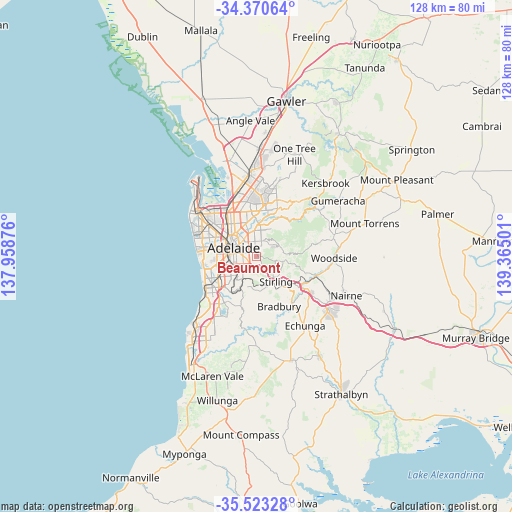
Beaumont GPS coordinates[2]
34° 56' 56.364" South, 138° 39' 42.768" East
| Map corner | latitude | longitude |
|---|---|---|
| Upper-left | -34.37064°, | 137.95876° |
| Center: | -34.94899°, | 138.66188° |
| Lower-right: | -35.52328°, | 139.36501° |
| Map W x H: | 128.2×128.2 km | = 79.7×79.7mi |
| max Lat: | -10.58257° ⇑69.8% North |
| Beaumont: | -34.94899° |
| min Lat: | ⇓30.2% South -43.31423° |
| min Long | Beaumont | max Long |
| 113.53327° | 138.66188° | 153.61246° |
| W 20.8%⇐ | ⇒79.2% E |
Elevation
Elevation of Beaumont is 202 m = 663 ft, and this is 80 m = 262 ft above average elevation for this country.
| Max E: |
1715 m = 5627 ft | 18.2% |
| Beaumont | 202 m 663 ft | |
| Avg. | 122 m = 400 ft | |
Min E: |
-2 m = -7 ft | 81.8% |
See also: Australia elevation on elevation.city.
Geographical zone
Beaumont is located in South temperate zone (between Tropic of Capricorn and the Antarctic Circle). Distance of this Southern Tropic circle is 1280 km =795.4 mi to North.| Distance of | km | miles | from Beaumont |
|---|---|---|---|
| Equator | 3886 | 2414.6 | to North |
| Tropic Capricorn | 1280 | 795.4 | to North |
| Antarctic Circle | 3515.2 | 2184.2 | to South |
| South Pole | 6121.1 | 3803.5 | to South |


Nearby cities:
15 places around Beaumont: (largest is in red/bold)
• Erindale
2.4 km =1.5 mi,  2°
2°
• Glen Osmond
1.7 km =1.1 mi,  225°
225°
• Glenside
2.7 km =1.7 mi,  285°
285°
• Glenunga
2.1 km =1.3 mi,  266°
266°
• Hazelwood Park
1.1 km =0.7 mi,  345°
345°
• Heathpool
2.4 km =1.5 mi,  323°
323°
• Kensington Gardens
2.6 km =1.6 mi,  359°
359°
• Leabrook
2.2 km =1.4 mi, 352°
• Linden Park
1.5 km =0.9 mi, 294°
• Marryatville
2.7 km =1.7 mi,  327°
327°
• St Georges
1.3 km =0.8 mi,  255°
255°
• Stonyfell
2.1 km =1.3 mi,  39°
39°
• Toorak Gardens
2.8 km =1.7 mi,  304°
304°
• Tusmore
1.5 km =0.9 mi, 317°
• Urrbrae
2.6 km =1.6 mi,  222°
222°
Sources, notices
• [Note1] Compared only with cities in Australia existing in our database
• [Src1] Map data: © OpenStreetMap contributors (CC-BY-SA)
• [Src2] Other city data from geonames.org with taken over terms of usage.
• [Src3] Geographical zone / Annual Mean Temperature by Robert A. Rohde @ Wikipedia
