Urrbrae geodata
Urrbrae (South Australia) is a section of populated place; located in Australia in Australia/Adelaide (GMT+10.5) time zone. With population of 941 people, there are 3913 cities with bigger population in this country. Compared to other cities in Australia, 70.4% of cities are located further ↑North; 79.9% of cities are located further →East and 78.5% of cities have lower elevation than Urrbrae. Note1


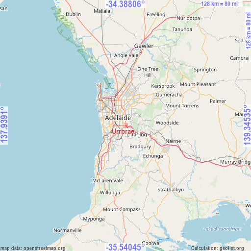
Urrbrae GPS coordinates[2]
34° 57' 58.608" South, 138° 38' 31.992" East
| Map corner | latitude | longitude |
|---|---|---|
| Upper-left | -34.38806°, | 137.9391° |
| Center: | -34.96628°, | 138.64222° |
| Lower-right: | -35.54045°, | 139.34535° |
| Map W x H: | 128.1×128.1 km | = 79.6×79.6mi |
| max Lat: | -10.58257° ⇑70.4% North |
| Urrbrae: | -34.96628° |
| min Lat: | ⇓29.6% South -43.31423° |
| min Long | Urrbrae | max Long |
| 113.53327° | 138.64222° | 153.61246° |
| W 20.1%⇐ | ⇒79.9% E |
Elevation
Elevation of Urrbrae is 161 m = 528 ft, and this is 39 m = 128 ft above average elevation for this country.
| Max E: |
1715 m = 5627 ft | 21.5% |
| Urrbrae | 161 m 528 ft | |
| Avg. | 122 m = 400 ft | |
Min E: |
-2 m = -7 ft | 78.5% |
See also: Australia elevation on elevation.city.
Geographical zone
Urrbrae is located in South temperate zone (between Tropic of Capricorn and the Antarctic Circle). Distance of this Southern Tropic circle is 1282 km =796.6 mi to North.| Distance of | km | miles | from Urrbrae |
|---|---|---|---|
| Equator | 3887.9 | 2415.8 | to North |
| Tropic Capricorn | 1282 | 796.6 | to North |
| Antarctic Circle | 3513.3 | 2183.1 | to South |
| South Pole | 6119.2 | 3802.3 | to South |


Nearby cities:
15 places around Urrbrae: (largest is in red/bold)
• Beaumont
2.6 km =1.6 mi,  42°
42°
• Frewville
2.3 km =1.4 mi,  332°
332°
• Fullarton
2.1 km =1.3 mi,  324°
324°
• Glen Osmond
1 km =0.6 mi, 38°
• Glenside
2.7 km =1.7 mi,  343°
343°
• Glenunga
1.8 km =1.1 mi,  349°
349°
• Highgate
1.9 km =1.2 mi,  285°
285°
• Linden Park
2.6 km =1.6 mi,  10°
10°
• Malvern
2.8 km =1.7 mi, 286°
• Mitcham
2.3 km =1.4 mi,  232°
232°
• Myrtle Bank
1 km =0.6 mi,  309°
309°
• Netherby
1.6 km =1 mi,  253°
253°
• Springfield
1.6 km =1 mi,  213°
213°
• St Georges
1.7 km =1.1 mi,  17°
17°
• Tusmore
3.1 km =1.9 mi, 14°
Sources, notices
• [Note1] Compared only with cities in Australia existing in our database
• [Src1] Map data: © OpenStreetMap contributors (CC-BY-SA)
• [Src2] Other city data from geonames.org with taken over terms of usage.
• [Src3] Geographical zone / Annual Mean Temperature by Robert A. Rohde @ Wikipedia
