Redcliffe geodata
Redcliffe (Western Australia) is a section of populated place; located in Australia in Australia/Perth (GMT+8) time zone. With population of 4,904 people, there are 1505 cities with bigger population in this country. Compared to other cities in Australia, 66% of cities are located further ↓South; 93.2% of cities are located further →East and 72.3% of cities have higher elevation than Redcliffe. Note1


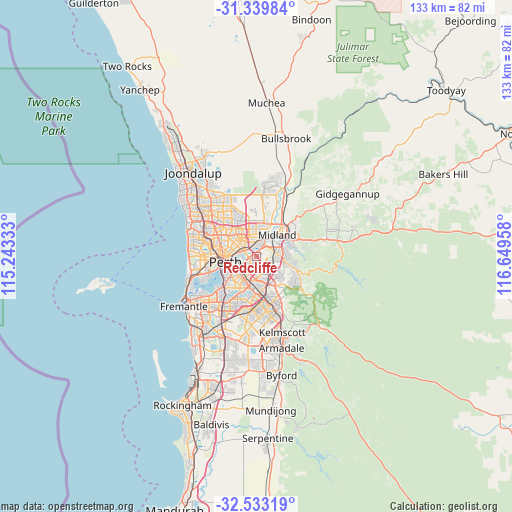
Redcliffe GPS coordinates[2]
31° 56' 18.42" South, 115° 56' 47.22" East
| Map corner | latitude | longitude |
|---|---|---|
| Upper-left | -31.33984°, | 115.24333° |
| Center: | -31.93845°, | 115.94645° |
| Lower-right: | -32.53319°, | 116.64958° |
| Map W x H: | 132.7×132.7 km | = 82.5×82.5mi |
| max Lat: | -10.58257° ⇑34% North |
| Redcliffe: | -31.93845° |
| min Lat: | ⇓66% South -43.31423° |
| min Long | Redcliffe | max Long |
| 113.53327° | 115.94645° | 153.61246° |
| W 6.8%⇐ | ⇒93.2% E |
Elevation
Elevation of Redcliffe is 21 m = 69 ft, and this is 101 m = 331 ft below average elevation for this country.
| Max E: |
1715 m = 5627 ft | 72.3% |
| Avg. | 122 m = 400 ft | |
| Redcliffe | 21 m = 69 ft | |
Min E: |
-2 m = -7 ft | 27.7% |
See also: Australia elevation on elevation.city.
Geographical zone
Redcliffe is located in South temperate zone (between Tropic of Capricorn and the Antarctic Circle). Distance of this Southern Tropic circle is 945.3 km =587.4 mi to North.| Distance of | km | miles | from Redcliffe |
|---|---|---|---|
| Equator | 3551.2 | 2206.6 | to North |
| Tropic Capricorn | 945.3 | 587.4 | to North |
| Antarctic Circle | 3850 | 2392.3 | to South |
| South Pole | 6455.8 | 4011.4 | to South |


Nearby cities:
15 places around Redcliffe: (largest is in red/bold)
• Ascot
2.3 km =1.4 mi,  270°
270°
• Ashfield
2.5 km =1.6 mi,  341°
341°
• Bassendean
3.3 km =2.1 mi,  355°
355°
• Bayswater
3.6 km =2.2 mi,  311°
311°
• Belmont
2.1 km =1.3 mi,  254°
254°
• Burswood
4.6 km =2.9 mi,  240°
240°
• Carlisle
5.3 km =3.3 mi,  210°
210°
• Cloverdale
2.7 km =1.7 mi,  184°
184°
• Embleton
5.2 km =3.2 mi,  317°
317°
• Guildford
4.7 km =2.9 mi,  24°
24°
• Kewdale
4.5 km =2.8 mi,  173°
173°
• Lathlain
5 km =3.1 mi,  229°
229°
• Maylands
4.9 km =3 mi,  279°
279°
• Rivervale
3.7 km =2.3 mi, 239°
• South Guildford
3.6 km =2.2 mi,  35°
35°
Sources, notices
• [Note1] Compared only with cities in Australia existing in our database
• [Src1] Map data: © OpenStreetMap contributors (CC-BY-SA)
• [Src2] Other city data from geonames.org with taken over terms of usage.
• [Src3] Geographical zone / Annual Mean Temperature by Robert A. Rohde @ Wikipedia
