Bayswater geodata
Bayswater (Western Australia) is a section of populated place; located in Australia in Australia/Perth (GMT+8) time zone. With population of 14,236 people, there are 303 cities with bigger population in this country. Compared to other cities in Australia, 66.4% of cities are located further ↓South; 93.6% of cities are located further →East and 83.5% of cities have higher elevation than Bayswater. Note1


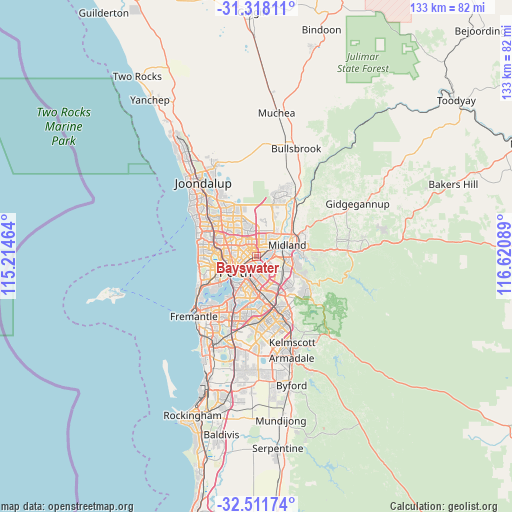
Bayswater GPS coordinates[2]
31° 55' 0.696" South, 115° 55' 3.936" East
| Map corner | latitude | longitude |
|---|---|---|
| Upper-left | -31.31811°, | 115.21464° |
| Center: | -31.91686°, | 115.91776° |
| Lower-right: | -32.51174°, | 116.62089° |
| Map W x H: | 132.7×132.7 km | = 82.5×82.5mi |
| max Lat: | -10.58257° ⇑33.6% North |
| Bayswater: | -31.91686° |
| min Lat: | ⇓66.4% South -43.31423° |
| min Long | Bayswater | max Long |
| 113.53327° | 115.91776° | 153.61246° |
| W 6.4%⇐ | ⇒93.6% E |
Elevation
Elevation of Bayswater is 13 m = 43 ft, and this is 109 m = 358 ft below average elevation for this country.
| Max E: |
1715 m = 5627 ft | 83.5% |
| Avg. | 122 m = 400 ft | |
| Bayswater | 13 m = 43 ft | |
Min E: |
-2 m = -7 ft | 16.5% |
See also: Australia elevation on elevation.city.
Geographical zone
Bayswater is located in South temperate zone (between Tropic of Capricorn and the Antarctic Circle). Distance of this Southern Tropic circle is 942.9 km =585.9 mi to North.| Distance of | km | miles | from Bayswater |
|---|---|---|---|
| Equator | 3548.8 | 2205.1 | to North |
| Tropic Capricorn | 942.9 | 585.9 | to North |
| Antarctic Circle | 3852.4 | 2393.8 | to South |
| South Pole | 6458.2 | 4012.9 | to South |


Nearby cities:
15 places around Bayswater: (largest is in red/bold)
• Ascot
2.4 km =1.5 mi,  169°
169°
• Ashfield
1.9 km =1.2 mi,  91°
91°
• Bassendean
2.6 km =1.6 mi,  70°
70°
• Bedford
2.8 km =1.7 mi,  282°
282°
• Belmont
3.1 km =1.9 mi, 166°
• Burswood
4.8 km =3 mi,  195°
195°
• Eden Hill
4.1 km =2.5 mi,  41°
41°
• Embleton
1.7 km =1.1 mi,  330°
330°
• Inglewood
3.6 km =2.2 mi,  270°
270°
• Kiara
4.4 km =2.7 mi,  26°
26°
• Maylands
2.7 km =1.7 mi,  234°
234°
• Morley
3.3 km =2.1 mi,  347°
347°
• Redcliffe
3.6 km =2.2 mi,  131°
131°
• Rivervale
4.3 km =2.7 mi,  185°
185°
• South Guildford
4.8 km =3 mi,  83°
83°
Sources, notices
• [Note1] Compared only with cities in Australia existing in our database
• [Src1] Map data: © OpenStreetMap contributors (CC-BY-SA)
• [Src2] Other city data from geonames.org with taken over terms of usage.
• [Src3] Geographical zone / Annual Mean Temperature by Robert A. Rohde @ Wikipedia
