Clapham geodata
Clapham (South Australia) is a section of populated place; located in Australia in Australia/Adelaide (GMT+10.5) time zone. With population of 1,592 people, there are 3196 cities with bigger population in this country. Compared to other cities in Australia, 71.1% of cities are located further ↑North; 81.4% of cities are located further →East and 62.4% of cities have lower elevation than Clapham. Note1


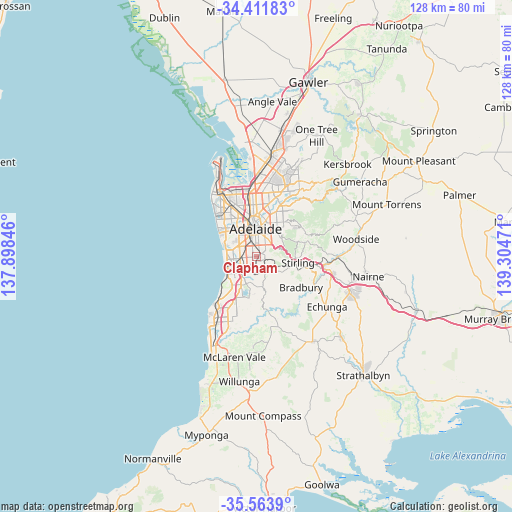
Clapham GPS coordinates[2]
34° 59' 23.604" South, 138° 36' 5.688" East
| Map corner | latitude | longitude |
|---|---|---|
| Upper-left | -34.41183°, | 137.89846° |
| Center: | -34.98989°, | 138.60158° |
| Lower-right: | -35.5639°, | 139.30471° |
| Map W x H: | 128.1×128.1 km | = 79.6×79.6mi |
| max Lat: | -10.58257° ⇑71.1% North |
| Clapham: | -34.98989° |
| min Lat: | ⇓28.9% South -43.31423° |
| min Long | Clapham | max Long |
| 113.53327° | 138.60158° | 153.61246° |
| W 18.6%⇐ | ⇒81.4% E |
Elevation
Elevation of Clapham is 71 m = 233 ft, and this is 51 m = 167 ft below average elevation for this country.
| Max E: |
1715 m = 5627 ft | 37.6% |
| Avg. | 122 m = 400 ft | |
| Clapham | 71 m = 233 ft | |
Min E: |
-2 m = -7 ft | 62.4% |
See also: Australia elevation on elevation.city.
Geographical zone
Clapham is located in South temperate zone (between Tropic of Capricorn and the Antarctic Circle). Distance of this Southern Tropic circle is 1284.6 km =798.2 mi to North.| Distance of | km | miles | from Clapham |
|---|---|---|---|
| Equator | 3890.5 | 2417.4 | to North |
| Tropic Capricorn | 1284.6 | 798.2 | to North |
| Antarctic Circle | 3510.7 | 2181.4 | to South |
| South Pole | 6116.6 | 3800.7 | to South |


Nearby cities:
15 places around Clapham: (largest is in red/bold)
• Belair
1.9 km =1.2 mi,  116°
116°
• Clarence Gardens
2.6 km =1.6 mi,  309°
309°
• Colonel Light Gardens
0.5 km =0.3 mi,  316°
316°
• Cumberland Park
2.4 km =1.5 mi,  325°
325°
• Daw Park
1.6 km =1 mi,  270°
270°
• Hawthorn
1.9 km =1.2 mi,  16°
16°
• Lower Mitcham
1.4 km =0.9 mi,  12°
12°
• Melrose Park
2.5 km =1.6 mi,  287°
287°
• Mitcham
2.2 km =1.4 mi,  56°
56°
• Panorama
0.2 km =0.1 mi,  242°
242°
• Pasadena
1.9 km =1.2 mi,  219°
219°
• St Marys
2.5 km =1.6 mi,  231°
231°
• Torrens Park
1.7 km =1.1 mi,  27°
27°
• Unley Park
2.9 km =1.8 mi, 11°
• Westbourne Park
2.1 km =1.3 mi,  344°
344°
Sources, notices
• [Note1] Compared only with cities in Australia existing in our database
• [Src1] Map data: © OpenStreetMap contributors (CC-BY-SA)
• [Src2] Other city data from geonames.org with taken over terms of usage.
• [Src3] Geographical zone / Annual Mean Temperature by Robert A. Rohde @ Wikipedia
