Belair geodata
Belair (South Australia) is a section of populated place; located in Australia in Australia/Adelaide (GMT+10.5) time zone. With population of 4,288 people, there are 1686 cities with bigger population in this country. Compared to other cities in Australia, 71.3% of cities are located further ↑North; 80.7% of cities are located further →East and 87.9% of cities have lower elevation than Belair. Note1


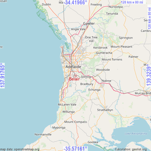
Belair GPS coordinates[2]
34° 59' 51.576" South, 138° 37' 14.772" East
| Map corner | latitude | longitude |
|---|---|---|
| Upper-left | -34.41966°, | 137.91765° |
| Center: | -34.99766°, | 138.62077° |
| Lower-right: | -35.57161°, | 139.3239° |
| Map W x H: | 128.1×128.1 km | = 79.6×79.6mi |
| max Lat: | -10.58257° ⇑71.3% North |
| Belair: | -34.99766° |
| min Lat: | ⇓28.7% South -43.31423° |
| min Long | Belair | max Long |
| 113.53327° | 138.62077° | 153.61246° |
| W 19.3%⇐ | ⇒80.7% E |
Elevation
Elevation of Belair is 311 m = 1020 ft, and this is 189 m = 620 ft above average elevation for this country.
| Max E: |
1715 m = 5627 ft | 12.1% |
| Belair | 311 m 1020 ft | |
| Avg. | 122 m = 400 ft | |
Min E: |
-2 m = -7 ft | 87.9% |
See also: Australia elevation on elevation.city.
Geographical zone
Belair is located in South temperate zone (between Tropic of Capricorn and the Antarctic Circle). Distance of this Southern Tropic circle is 1285.5 km =798.8 mi to North.| Distance of | km | miles | from Belair |
|---|---|---|---|
| Equator | 3891.4 | 2418 | to North |
| Tropic Capricorn | 1285.5 | 798.8 | to North |
| Antarctic Circle | 3509.8 | 2180.9 | to South |
| South Pole | 6115.7 | 3800.1 | to South |


Nearby cities:
15 places around Belair: (largest is in red/bold)
• Blackwood
2.7 km =1.7 mi,  192°
192°
• Clapham
1.9 km =1.2 mi,  296°
296°
• Colonel Light Gardens
2.5 km =1.6 mi, 300°
• Daw Park
3.5 km =2.2 mi,  284°
284°
• Eden Hills
3.5 km =2.2 mi,  221°
221°
• Glenalta
1.2 km =0.7 mi,  157°
157°
• Hawthorn
2.9 km =1.8 mi,  335°
335°
• Hawthorndene
2.9 km =1.8 mi, 162°
• Lower Mitcham
2.7 km =1.7 mi,  327°
327°
• Mitcham
2.1 km =1.3 mi,  2°
2°
• Netherby
3 km =1.9 mi,  7°
7°
• Panorama
2.1 km =1.3 mi,  291°
291°
• Pasadena
3 km =1.9 mi,  259°
259°
• Springfield
2.4 km =1.5 mi,  26°
26°
• Torrens Park
2.6 km =1.6 mi, 338°
Sources, notices
• [Note1] Compared only with cities in Australia existing in our database
• [Src1] Map data: © OpenStreetMap contributors (CC-BY-SA)
• [Src2] Other city data from geonames.org with taken over terms of usage.
• [Src3] Geographical zone / Annual Mean Temperature by Robert A. Rohde @ Wikipedia
