Mitcham geodata
Mitcham (South Australia) is a seat of a second-order administrative division; located in Australia in Australia/Adelaide (GMT+10.5) time zone. With population of 1,792 people, there are 3055 cities with bigger population in this country. Compared to other cities in Australia, 70.8% of cities are located further ↑North; 80.6% of cities are located further →East and 69.2% of cities have lower elevation than Mitcham. Note1


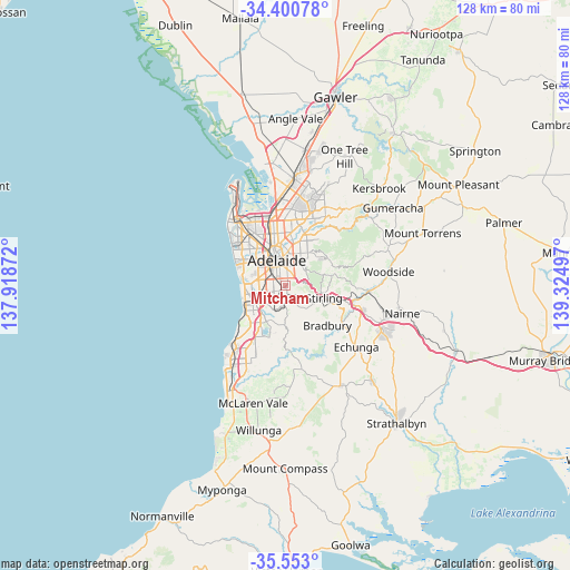
Mitcham GPS coordinates[2]
34° 58' 44.112" South, 138° 37' 18.624" East
| Map corner | latitude | longitude |
|---|---|---|
| Upper-left | -34.40078°, | 137.91872° |
| Center: | -34.97892°, | 138.62184° |
| Lower-right: | -35.553°, | 139.32497° |
| Map W x H: | 128.1×128.1 km | = 79.6×79.6mi |
| max Lat: | -10.58257° ⇑70.8% North |
| Mitcham: | -34.97892° |
| min Lat: | ⇓29.2% South -43.31423° |
| min Long | Mitcham | max Long |
| 113.53327° | 138.62184° | 153.61246° |
| W 19.4%⇐ | ⇒80.6% E |
Elevation
Elevation of Mitcham is 98 m = 322 ft, and this is 24 m = 79 ft below average elevation for this country.
| Max E: |
1715 m = 5627 ft | 30.8% |
| Avg. | 122 m = 400 ft | |
| Mitcham | 98 m = 322 ft | |
Min E: |
-2 m = -7 ft | 69.2% |
See also: Australia elevation on elevation.city.
Geographical zone
Mitcham is located in South temperate zone (between Tropic of Capricorn and the Antarctic Circle). Distance of this Southern Tropic circle is 1283.4 km =797.5 mi to North.| Distance of | km | miles | from Mitcham |
|---|---|---|---|
| Equator | 3889.3 | 2416.7 | to North |
| Tropic Capricorn | 1283.4 | 797.5 | to North |
| Antarctic Circle | 3511.9 | 2182.2 | to South |
| South Pole | 6117.8 | 3801.4 | to South |


Nearby cities:
15 places around Mitcham: (largest is in red/bold)
• Belair
2.1 km =1.3 mi,  182°
182°
• Clapham
2.2 km =1.4 mi,  236°
236°
• Colonel Light Gardens
2.4 km =1.5 mi,  249°
249°
• Hawthorn
1.4 km =0.9 mi,  293°
293°
• Highgate
1.9 km =1.2 mi,  359°
359°
• Lower Mitcham
1.6 km =1 mi,  276°
276°
• Malvern
2.4 km =1.5 mi,  338°
338°
• Myrtle Bank
2.3 km =1.4 mi,  28°
28°
• Netherby
1 km =0.6 mi,  17°
17°
• Panorama
2.4 km =1.5 mi, 237°
• Springfield
1 km =0.6 mi,  85°
85°
• Torrens Park
1.1 km =0.7 mi, 286°
• Unley Park
2.1 km =1.3 mi,  322°
322°
• Urrbrae
2.3 km =1.4 mi,  52°
52°
• Westbourne Park
2.6 km =1.6 mi, 288°
Sources, notices
• [Note1] Compared only with cities in Australia existing in our database
• [Src1] Map data: © OpenStreetMap contributors (CC-BY-SA)
• [Src2] Other city data from geonames.org with taken over terms of usage.
• [Src3] Geographical zone / Annual Mean Temperature by Robert A. Rohde @ Wikipedia
