Wodonga geodata
Wodonga (Victoria) is a populated place; located in Australia in Australia/Melbourne (GMT+11) time zone. With population of 18,582 people, there are 185 cities with bigger population in this country. Compared to other cities in Australia, 78.9% of cities are located further ↑North; 53.7% of cities are located further →East and 78.9% of cities have lower elevation than Wodonga. Note1


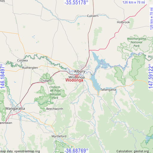
Wodonga GPS coordinates[2]
36° 7' 18.444" South, 146° 53' 17.124" East
| Map corner | latitude | longitude |
|---|---|---|
| Upper-left | -35.55178°, | 146.18497° |
| Center: | -36.12179°, | 146.88809° |
| Lower-right: | -36.68769°, | 147.59122° |
| Map W x H: | 126.3×126.3 km | = 78.5×78.5mi |
| max Lat: | -10.58257° ⇑78.9% North |
| Wodonga: | -36.12179° |
| min Lat: | ⇓21.1% South -43.31423° |
| min Long | Wodonga | max Long |
| 113.53327° | 146.88809° | 153.61246° |
| W 46.3%⇐ | ⇒53.7% E |
Elevation
Elevation of Wodonga is 167 m = 548 ft, and this is 45 m = 148 ft above average elevation for this country.
| Max E: |
1715 m = 5627 ft | 21.1% |
| Wodonga | 167 m 548 ft | |
| Avg. | 122 m = 400 ft | |
Min E: |
-2 m = -7 ft | 78.9% |
See also: Australia elevation on elevation.city.
Geographical zone
Wodonga is located in South temperate zone (between Tropic of Capricorn and the Antarctic Circle). Distance of this Southern Tropic circle is 1410.4 km =876.4 mi to North.| Distance of | km | miles | from Wodonga |
|---|---|---|---|
| Equator | 4016.4 | 2495.7 | to North |
| Tropic Capricorn | 1410.4 | 876.4 | to North |
| Antarctic Circle | 3384.8 | 2103.2 | to South |
| South Pole | 5990.7 | 3722.4 | to South |


Nearby cities:
15 places around Wodonga: (largest is in red/bold)
• Albury
6.1 km =3.8 mi,  31°
31°
• Bandiana
4.5 km =2.8 mi,  130°
130°
• Baranduda
9.7 km =6 mi,  142°
142°
• Bonegilla
10.8 km =6.7 mi,  100°
100°
• East Albury
5.9 km =3.7 mi,  39°
39°
• Glenroy
8.2 km =5.1 mi,  14°
14°
• Hamilton Valley
9.7 km =6 mi,  15°
15°
• Killara
6 km =3.7 mi,  109°
109°
• Lavington
10.2 km =6.3 mi, 26°
• Leneva
10.6 km =6.6 mi,  174°
174°
• North Albury
8.1 km =5 mi, 27°
• South Albury
4.3 km =2.7 mi, 25°
• Springdale Heights
11.4 km =7.1 mi, 27°
• West Albury
4.7 km =2.9 mi,  4°
4°
• West Wodonga
3.3 km =2.1 mi,  266°
266°
Sources, notices
• [Note1] Compared only with cities in Australia existing in our database
• [Src1] Map data: © OpenStreetMap contributors (CC-BY-SA)
• [Src2] Other city data from geonames.org with taken over terms of usage.
• [Src3] Geographical zone / Annual Mean Temperature by Robert A. Rohde @ Wikipedia
