Glenroy geodata
Glenroy (New South Wales) is a section of populated place; located in Australia in Australia/Sydney (GMT+11) time zone. With population of 3,179 people, there are 2141 cities with bigger population in this country. Compared to other cities in Australia, 78.5% of cities are located further ↑North; 53.6% of cities are located further →East and 80.8% of cities have lower elevation than Glenroy. Note1


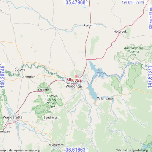
Glenroy GPS coordinates[2]
36° 3' 0.756" South, 146° 54' 38.088" East
| Map corner | latitude | longitude |
|---|---|---|
| Upper-left | -35.47968°, | 146.20746° |
| Center: | -36.05021°, | 146.91058° |
| Lower-right: | -36.61663°, | 147.61371° |
| Map W x H: | 126.4×126.4 km | = 78.5×78.5mi |
| max Lat: | -10.58257° ⇑78.5% North |
| Glenroy: | -36.05021° |
| min Lat: | ⇓21.5% South -43.31423° |
| min Long | Glenroy | max Long |
| 113.53327° | 146.91058° | 153.61246° |
| W 46.4%⇐ | ⇒53.6% E |
Elevation
Elevation of Glenroy is 191 m = 627 ft, and this is 69 m = 226 ft above average elevation for this country.
| Max E: |
1715 m = 5627 ft | 19.2% |
| Glenroy | 191 m 627 ft | |
| Avg. | 122 m = 400 ft | |
Min E: |
-2 m = -7 ft | 80.8% |
See also: Australia elevation on elevation.city.
Geographical zone
Glenroy is located in South temperate zone (between Tropic of Capricorn and the Antarctic Circle). Distance of this Southern Tropic circle is 1402.5 km =871.5 mi to North.| Distance of | km | miles | from Glenroy |
|---|---|---|---|
| Equator | 4008.4 | 2490.7 | to North |
| Tropic Capricorn | 1402.5 | 871.5 | to North |
| Antarctic Circle | 3392.8 | 2108.2 | to South |
| South Pole | 5998.7 | 3727.4 | to South |


Nearby cities:
15 places around Glenroy: (largest is in red/bold)
• Albury
3 km =1.9 mi,  156°
156°
• Bandiana
10.9 km =6.8 mi,  172°
172°
• East Albury
3.9 km =2.4 mi,  153°
153°
• Hamilton Valley
1.5 km =0.9 mi,  24°
24°
• Jindera
10.8 km =6.7 mi,  349°
349°
• Killara
10.6 km =6.6 mi, 159°
• Lavington
2.9 km =1.8 mi,  65°
65°
• North Albury
1.9 km =1.2 mi,  114°
114°
• South Albury
4 km =2.5 mi,  181°
181°
• Springdale Heights
4 km =2.5 mi,  57°
57°
• Table Top
12.3 km =7.6 mi,  40°
40°
• Thurgoona
7.8 km =4.8 mi,  78°
78°
• West Albury
3.7 km =2.3 mi,  206°
206°
• West Wodonga
9.7 km =6 mi, 212°
• Wodonga
8.2 km =5.1 mi,  194°
194°
Sources, notices
• [Note1] Compared only with cities in Australia existing in our database
• [Src1] Map data: © OpenStreetMap contributors (CC-BY-SA)
• [Src2] Other city data from geonames.org with taken over terms of usage.
• [Src3] Geographical zone / Annual Mean Temperature by Robert A. Rohde @ Wikipedia
