Leneva geodata
Leneva (Victoria) is a populated place; located in Australia in Australia/Melbourne (GMT+11) time zone. With population of 841 people, there are 4074 cities with bigger population in this country. Compared to other cities in Australia, 79.1% of cities are located further ↑North; 53.7% of cities are located further →East and 90.1% of cities have lower elevation than Leneva. Note1


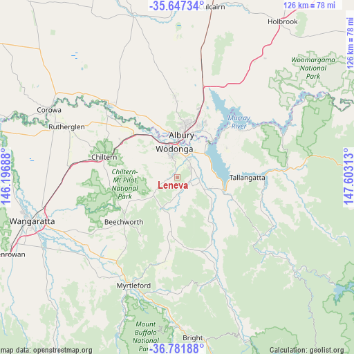
Leneva GPS coordinates[2]
36° 13' 0.012" South, 146° 54' 0" East
| Map corner | latitude | longitude |
|---|---|---|
| Upper-left | -35.64734°, | 146.19688° |
| Center: | -36.21667°, | 146.9° |
| Lower-right: | -36.78188°, | 147.60313° |
| Map W x H: | 126.1×126.1 km | = 78.4×78.4mi |
| max Lat: | -10.58257° ⇑79.1% North |
| Leneva: | -36.21667° |
| min Lat: | ⇓20.9% South -43.31423° |
| min Long | Leneva | max Long |
| 113.53327° | 146.9° | 153.61246° |
| W 46.3%⇐ | ⇒53.7% E |
Elevation
Elevation of Leneva is 379 m = 1243 ft, and this is 257 m = 843 ft above average elevation for this country.
| Max E: |
1715 m = 5627 ft | 9.9% |
| Leneva | 379 m 1243 ft | |
| Avg. | 122 m = 400 ft | |
Min E: |
-2 m = -7 ft | 90.1% |
See also: Australia elevation on elevation.city.
Geographical zone
Leneva is located in South temperate zone (between Tropic of Capricorn and the Antarctic Circle). Distance of this Southern Tropic circle is 1421 km =883 mi to North.| Distance of | km | miles | from Leneva |
|---|---|---|---|
| Equator | 4026.9 | 2502.2 | to North |
| Tropic Capricorn | 1421 | 883 | to North |
| Antarctic Circle | 3374.3 | 2096.7 | to South |
| South Pole | 5980.1 | 3715.9 | to South |


Nearby cities:
15 places around Leneva: (largest is in red/bold)
• Albury
15.9 km =9.9 mi,  7°
7°
• Bandiana
8 km =5 mi,  17°
17°
• Baranduda
5.6 km =3.5 mi,  59°
59°
• Bonegilla
12.8 km =8 mi,  48°
48°
• East Albury
15.3 km =9.5 mi, 10°
• Glenroy
18.5 km =11.5 mi,  2°
2°
• Hamilton Valley
19.9 km =12.4 mi, 4°
• Killara
9.7 km =6 mi,  28°
28°
• North Albury
17.9 km =11.1 mi, 8°
• South Albury
14.5 km =9 mi, 3°
• Tangambalanga
12.2 km =7.6 mi,  108°
108°
• West Albury
15.2 km =9.4 mi,  357°
357°
• West Wodonga
11.2 km =7 mi,  337°
337°
• Wodonga
10.6 km =6.6 mi,  354°
354°
• Yackandandah
12.1 km =7.5 mi,  206°
206°
Sources, notices
• [Note1] Compared only with cities in Australia existing in our database
• [Src1] Map data: © OpenStreetMap contributors (CC-BY-SA)
• [Src2] Other city data from geonames.org with taken over terms of usage.
• [Src3] Geographical zone / Annual Mean Temperature by Robert A. Rohde @ Wikipedia
