Killara geodata
Killara (Victoria) is a populated place; located in Australia in Australia/Melbourne (GMT+11) time zone. With population of 613 people, there are 4538 cities with bigger population in this country. Compared to other cities in Australia, 78.9% of cities are located further ↑North; 53.3% of cities are located further →East and 78.6% of cities have lower elevation than Killara. Note1


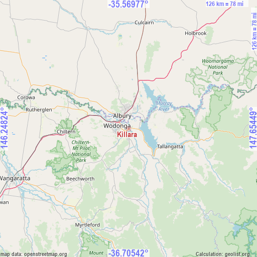
Killara GPS coordinates[2]
36° 8' 22.74" South, 146° 57' 4.896" East
| Map corner | latitude | longitude |
|---|---|---|
| Upper-left | -35.56977°, | 146.24824° |
| Center: | -36.13965°, | 146.95136° |
| Lower-right: | -36.70542°, | 147.65449° |
| Map W x H: | 126.3×126.3 km | = 78.5×78.5mi |
| max Lat: | -10.58257° ⇑78.9% North |
| Killara: | -36.13965° |
| min Lat: | ⇓21.1% South -43.31423° |
| min Long | Killara | max Long |
| 113.53327° | 146.95136° | 153.61246° |
| W 46.7%⇐ | ⇒53.3% E |
Elevation
Elevation of Killara is 164 m = 538 ft, and this is 42 m = 138 ft above average elevation for this country.
| Max E: |
1715 m = 5627 ft | 21.4% |
| Killara | 164 m 538 ft | |
| Avg. | 122 m = 400 ft | |
Min E: |
-2 m = -7 ft | 78.6% |
See also: Australia elevation on elevation.city.
Geographical zone
Killara is located in South temperate zone (between Tropic of Capricorn and the Antarctic Circle). Distance of this Southern Tropic circle is 1412.4 km =877.6 mi to North.| Distance of | km | miles | from Killara |
|---|---|---|---|
| Equator | 4018.4 | 2496.9 | to North |
| Tropic Capricorn | 1412.4 | 877.6 | to North |
| Antarctic Circle | 3382.8 | 2102 | to South |
| South Pole | 5988.7 | 3721.2 | to South |


Nearby cities:
15 places around Killara: (largest is in red/bold)
• Albury
7.6 km =4.7 mi,  341°
341°
• Bandiana
2.4 km =1.5 mi,  248°
248°
• Baranduda
5.7 km =3.5 mi,  177°
177°
• Bonegilla
4.9 km =3 mi,  90°
90°
• East Albury
6.8 km =4.2 mi, 343°
• Glenroy
10.6 km =6.6 mi, 339°
• Hamilton Valley
11.7 km =7.3 mi,  345°
345°
• Lavington
11.2 km =7 mi, 354°
• Leneva
9.7 km =6 mi,  208°
208°
• North Albury
9.3 km =5.8 mi, 348°
• South Albury
7 km =4.3 mi,  327°
327°
• Springdale Heights
12.1 km =7.5 mi,  358°
358°
• West Albury
8.5 km =5.3 mi,  321°
321°
• West Wodonga
9.1 km =5.7 mi,  281°
281°
• Wodonga
6 km =3.7 mi,  289°
289°
Sources, notices
• [Note1] Compared only with cities in Australia existing in our database
• [Src1] Map data: © OpenStreetMap contributors (CC-BY-SA)
• [Src2] Other city data from geonames.org with taken over terms of usage.
• [Src3] Geographical zone / Annual Mean Temperature by Robert A. Rohde @ Wikipedia
