Ormeau Hills geodata
Ormeau Hills (Queensland) is a section of populated place; located in Australia in Australia/Brisbane (GMT+10) time zone. With population of 3,095 people, there are 2190 cities with bigger population in this country. Compared to other cities in Australia, 77.1% of cities are located further ↓South; 97.3% of cities are located further ←West and 52.4% of cities have higher elevation than Ormeau Hills. Note1


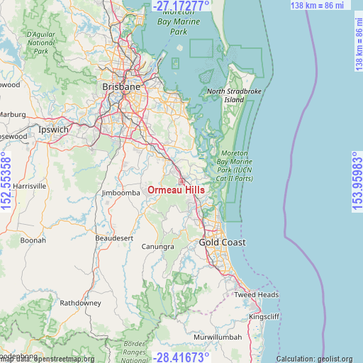
Ormeau Hills GPS coordinates[2]
27° 47' 47.508" South, 153° 15' 24.12" East
| Map corner | latitude | longitude |
|---|---|---|
| Upper-left | -27.17277°, | 152.55358° |
| Center: | -27.79653°, | 153.2567° |
| Lower-right: | -28.41673°, | 153.95983° |
| Map W x H: | 138.3×138.3 km | = 85.9×85.9mi |
| max Lat: | -10.58257° ⇑22.9% North |
| Ormeau Hills: | -27.79653° |
| min Lat: | ⇓77.1% South -43.31423° |
| min Long | Ormeau Hills | max Long |
| 113.53327° | 153.2567° | 153.61246° |
| W 97.3%⇐ | ⇒2.7% E |
Elevation
Elevation of Ormeau Hills is 42 m = 138 ft, and this is 80 m = 262 ft below average elevation for this country.
| Max E: |
1715 m = 5627 ft | 52.4% |
| Avg. | 122 m = 400 ft | |
| Ormeau Hills | 42 m = 138 ft | |
Min E: |
-2 m = -7 ft | 47.6% |
See also: Australia elevation on elevation.city.
Geographical zone
Ormeau Hills is located in South temperate zone (between Tropic of Capricorn and the Antarctic Circle). Distance of this Southern Tropic circle is 484.8 km =301.2 mi to North.| Distance of | km | miles | from Ormeau Hills |
|---|---|---|---|
| Equator | 3090.7 | 1920.5 | to North |
| Tropic Capricorn | 484.8 | 301.2 | to North |
| Antarctic Circle | 4310.5 | 2678.4 | to South |
| South Pole | 6916.4 | 4297.7 | to South |


Nearby cities:
15 places around Ormeau Hills: (largest is in red/bold)
• Alberton
10.8 km =6.7 mi,  356°
356°
• Bannockburn
7.5 km =4.7 mi,  302°
302°
• Beenleigh
10.8 km =6.7 mi,  330°
330°
• Cedar Creek
9.2 km =5.7 mi,  217°
217°
• Coomera
9.6 km =6 mi,  122°
122°
• Jacobs Well
10.5 km =6.5 mi,  79°
79°
• Mount Warren Park
8.9 km =5.5 mi, 325°
• Ormeau
3.5 km =2.2 mi,  336°
336°
• Pimpama
4.8 km =3 mi, 117°
• Steiglitz
10.5 km =6.5 mi,  60°
60°
• Upper Coomera
9.4 km =5.8 mi,  162°
162°
• Willow Vale
5.4 km =3.4 mi,  173°
173°
• Windaroo
8.4 km =5.2 mi,  312°
312°
• Wongawallan
9.2 km =5.7 mi,  197°
197°
• Yatala
9.7 km =6 mi, 336°
Sources, notices
• [Note1] Compared only with cities in Australia existing in our database
• [Src1] Map data: © OpenStreetMap contributors (CC-BY-SA)
• [Src2] Other city data from geonames.org with taken over terms of usage.
• [Src3] Geographical zone / Annual Mean Temperature by Robert A. Rohde @ Wikipedia
