Williamstown geodata
Williamstown (Victoria) is a section of populated place; located in Australia in Australia/Melbourne (GMT+11) time zone. With population of 13,869 people, there are 321 cities with bigger population in this country. Compared to other cities in Australia, 89.5% of cities are located further ↑North; 67.9% of cities are located further →East and 83.5% of cities have higher elevation than Williamstown. Note1


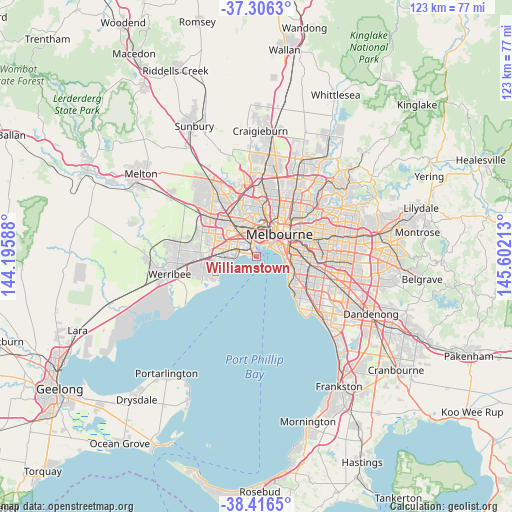
Williamstown GPS coordinates[2]
37° 51' 48.564" South, 144° 53' 56.4" East
| Map corner | latitude | longitude |
|---|---|---|
| Upper-left | -37.3063°, | 144.19588° |
| Center: | -37.86349°, | 144.899° |
| Lower-right: | -38.4165°, | 145.60213° |
| Map W x H: | 123.4×123.4 km | = 76.7×76.7mi |
| max Lat: | -10.58257° ⇑89.5% North |
| Williamstown: | -37.86349° |
| min Lat: | ⇓10.5% South -43.31423° |
| min Long | Williamstown | max Long |
| 113.53327° | 144.899° | 153.61246° |
| W 32.1%⇐ | ⇒67.9% E |
Elevation
Elevation of Williamstown is 13 m = 43 ft, and this is 109 m = 358 ft below average elevation for this country.
| Max E: |
1715 m = 5627 ft | 83.5% |
| Avg. | 122 m = 400 ft | |
| Williamstown | 13 m = 43 ft | |
Min E: |
-2 m = -7 ft | 16.5% |
See also: Australia elevation on elevation.city.
Geographical zone
Williamstown is located in South temperate zone (between Tropic of Capricorn and the Antarctic Circle). Distance of this Southern Tropic circle is 1604.1 km =996.7 mi to North.| Distance of | km | miles | from Williamstown |
|---|---|---|---|
| Equator | 4210 | 2616 | to North |
| Tropic Capricorn | 1604.1 | 996.7 | to North |
| Antarctic Circle | 3191.1 | 1982.9 | to South |
| South Pole | 5797 | 3602.1 | to South |


Nearby cities:
15 places around Williamstown: (largest is in red/bold)
• Albert Park
5.3 km =3.3 mi,  61°
61°
• Altona
6.1 km =3.8 mi,  263°
263°
• Altona North
5.5 km =3.4 mi,  305°
305°
• Kingsville
6.4 km =4 mi,  344°
344°
• Middle Park
5.7 km =3.5 mi,  76°
76°
• Newport
2.5 km =1.6 mi,  329°
329°
• Port Melbourne
4.6 km =2.9 mi, 55°
• Seaholme
4.7 km =2.9 mi,  269°
269°
• Seddon
6.4 km =4 mi,  353°
353°
• South Kingsville
4.5 km =2.8 mi, 326°
• South Wharf
6.3 km =3.9 mi,  47°
47°
• Spotswood
3.9 km =2.4 mi, 342°
• St Kilda West
6.3 km =3.9 mi,  86°
86°
• Williamstown North
1.7 km =1.1 mi,  302°
302°
• Yarraville
5.2 km =3.2 mi,  0°
0°
Sources, notices
• [Note1] Compared only with cities in Australia existing in our database
• [Src1] Map data: © OpenStreetMap contributors (CC-BY-SA)
• [Src2] Other city data from geonames.org with taken over terms of usage.
• [Src3] Geographical zone / Annual Mean Temperature by Robert A. Rohde @ Wikipedia
