Spotswood geodata
Spotswood (Victoria) is a section of populated place; located in Australia in Australia/Melbourne (GMT+11) time zone. With population of 2,578 people, there are 2513 cities with bigger population in this country. Compared to other cities in Australia, 88.5% of cities are located further ↑North; 68.1% of cities are located further →East and 74.7% of cities have higher elevation than Spotswood. Note1


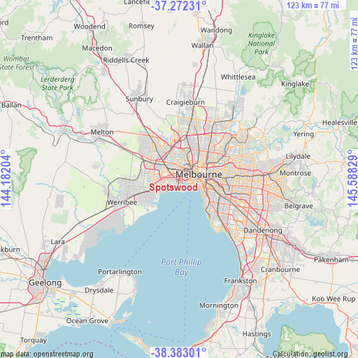
Spotswood GPS coordinates[2]
37° 49' 47.1" South, 144° 53' 6.576" East
| Map corner | latitude | longitude |
|---|---|---|
| Upper-left | -37.27231°, | 144.18204° |
| Center: | -37.82975°, | 144.88516° |
| Lower-right: | -38.38301°, | 145.58829° |
| Map W x H: | 123.5×123.5 km | = 76.7×76.7mi |
| max Lat: | -10.58257° ⇑88.5% North |
| Spotswood: | -37.82975° |
| min Lat: | ⇓11.5% South -43.31423° |
| min Long | Spotswood | max Long |
| 113.53327° | 144.88516° | 153.61246° |
| W 31.9%⇐ | ⇒68.1% E |
Elevation
Elevation of Spotswood is 19 m = 62 ft, and this is 103 m = 338 ft below average elevation for this country.
| Max E: |
1715 m = 5627 ft | 74.7% |
| Avg. | 122 m = 400 ft | |
| Spotswood | 19 m = 62 ft | |
Min E: |
-2 m = -7 ft | 25.3% |
See also: Australia elevation on elevation.city.
Geographical zone
Spotswood is located in South temperate zone (between Tropic of Capricorn and the Antarctic Circle). Distance of this Southern Tropic circle is 1600.4 km =994.4 mi to North.| Distance of | km | miles | from Spotswood |
|---|---|---|---|
| Equator | 4206.3 | 2613.7 | to North |
| Tropic Capricorn | 1600.4 | 994.4 | to North |
| Antarctic Circle | 3194.9 | 1985.2 | to South |
| South Pole | 5800.8 | 3604.4 | to South |


Nearby cities:
15 places around Spotswood: (largest is in red/bold)
• Altona North
3.4 km =2.1 mi,  260°
260°
• Braybrook
5.5 km =3.4 mi,  330°
330°
• Brooklyn
4.1 km =2.5 mi,  291°
291°
• Footscray
3.6 km =2.2 mi,  21°
21°
• Kingsville
2.5 km =1.6 mi,  347°
347°
• Maidstone
5.6 km =3.5 mi, 349°
• Newport
1.6 km =1 mi,  181°
181°
• Port Melbourne
5.1 km =3.2 mi,  102°
102°
• Seaholme
5.2 km =3.2 mi,  222°
222°
• Seddon
2.7 km =1.7 mi,  10°
10°
• South Kingsville
1.3 km =0.8 mi,  267°
267°
• West Footscray
3.7 km =2.3 mi, 349°
• Williamstown
3.9 km =2.4 mi,  162°
162°
• Williamstown North
2.8 km =1.7 mi, 184°
• Yarraville
2 km =1.2 mi,  41°
41°
Sources, notices
• [Note1] Compared only with cities in Australia existing in our database
• [Src1] Map data: © OpenStreetMap contributors (CC-BY-SA)
• [Src2] Other city data from geonames.org with taken over terms of usage.
• [Src3] Geographical zone / Annual Mean Temperature by Robert A. Rohde @ Wikipedia
