Seddon geodata
Seddon (Victoria) is a section of populated place; located in Australia in Australia/Melbourne (GMT+11) time zone. With population of 5,048 people, there are 1463 cities with bigger population in this country. Compared to other cities in Australia, 87.7% of cities are located further ↑North; 68% of cities are located further →East and 68.6% of cities have higher elevation than Seddon. Note1


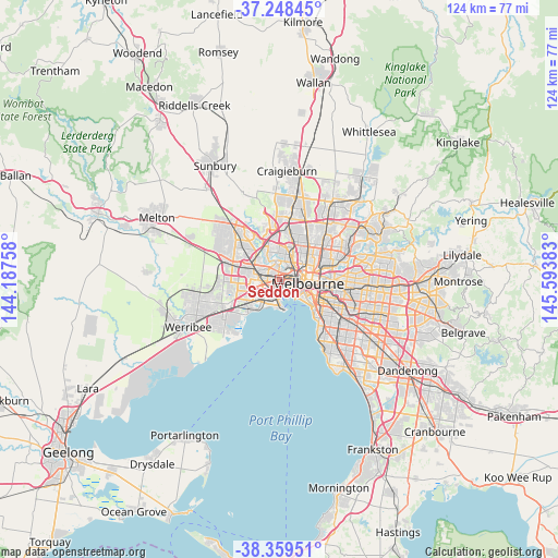
Seddon GPS coordinates[2]
37° 48' 21.852" South, 144° 53' 26.52" East
| Map corner | latitude | longitude |
|---|---|---|
| Upper-left | -37.24845°, | 144.18758° |
| Center: | -37.80607°, | 144.8907° |
| Lower-right: | -38.35951°, | 145.59383° |
| Map W x H: | 123.5×123.5 km | = 76.7×76.7mi |
| max Lat: | -10.58257° ⇑87.7% North |
| Seddon: | -37.80607° |
| min Lat: | ⇓12.3% South -43.31423° |
| min Long | Seddon | max Long |
| 113.53327° | 144.8907° | 153.61246° |
| W 32%⇐ | ⇒68% E |
Elevation
Elevation of Seddon is 24 m = 79 ft, and this is 98 m = 322 ft below average elevation for this country.
| Max E: |
1715 m = 5627 ft | 68.6% |
| Avg. | 122 m = 400 ft | |
| Seddon | 24 m = 79 ft | |
Min E: |
-2 m = -7 ft | 31.4% |
See also: Australia elevation on elevation.city.
Geographical zone
Seddon is located in South temperate zone (between Tropic of Capricorn and the Antarctic Circle). Distance of this Southern Tropic circle is 1597.7 km =992.8 mi to North.| Distance of | km | miles | from Seddon |
|---|---|---|---|
| Equator | 4203.6 | 2612 | to North |
| Tropic Capricorn | 1597.7 | 992.8 | to North |
| Antarctic Circle | 3197.5 | 1986.8 | to South |
| South Pole | 5803.4 | 3606.1 | to South |


Nearby cities:
15 places around Seddon: (largest is in red/bold)
• Ascot Vale
4.1 km =2.5 mi,  44°
44°
• Braybrook
3.8 km =2.4 mi,  304°
304°
• Brooklyn
4.5 km =2.8 mi,  255°
255°
• Flemington
4 km =2.5 mi,  60°
60°
• Footscray
1.1 km =0.7 mi,  50°
50°
• Kensington
3.9 km =2.4 mi,  66°
66°
• Kingsville
1 km =0.6 mi, 256°
• Maidstone
3.2 km =2 mi,  332°
332°
• Maribyrnong
3.8 km =2.4 mi,  351°
351°
• Newport
4.3 km =2.7 mi,  186°
186°
• South Kingsville
3.2 km =2 mi,  212°
212°
• Spotswood
2.7 km =1.7 mi, 190°
• Travancore
4.8 km =3 mi, 54°
• West Footscray
1.5 km =0.9 mi,  309°
309°
• Yarraville
1.4 km =0.9 mi,  145°
145°
Sources, notices
• [Note1] Compared only with cities in Australia existing in our database
• [Src1] Map data: © OpenStreetMap contributors (CC-BY-SA)
• [Src2] Other city data from geonames.org with taken over terms of usage.
• [Src3] Geographical zone / Annual Mean Temperature by Robert A. Rohde @ Wikipedia
