Seaholme geodata
Seaholme (Victoria) is a section of populated place; located in Australia in Australia/Melbourne (GMT+11) time zone. With population of 1,885 people, there are 2982 cities with bigger population in this country. Compared to other cities in Australia, 89.5% of cities are located further ↑North; 68.5% of cities are located further →East and 95.5% of cities have higher elevation than Seaholme. Note1


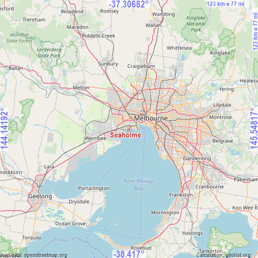
Seaholme GPS coordinates[2]
37° 51' 50.4" South, 144° 50' 42.144" East
| Map corner | latitude | longitude |
|---|---|---|
| Upper-left | -37.30682°, | 144.14192° |
| Center: | -37.864°, | 144.84504° |
| Lower-right: | -38.417°, | 145.54817° |
| Map W x H: | 123.4×123.4 km | = 76.7×76.7mi |
| max Lat: | -10.58257° ⇑89.5% North |
| Seaholme: | -37.864° |
| min Lat: | ⇓10.5% South -43.31423° |
| min Long | Seaholme | max Long |
| 113.53327° | 144.84504° | 153.61246° |
| W 31.5%⇐ | ⇒68.5% E |
Elevation
Elevation of Seaholme is 6 m = 20 ft, and this is 116 m = 381 ft below average elevation for this country.
| Max E: |
1715 m = 5627 ft | 95.5% |
| Avg. | 122 m = 400 ft | |
| Seaholme | 6 m = 20 ft | |
Min E: |
-2 m = -7 ft | 4.5% |
See also: Australia elevation on elevation.city.
Geographical zone
Seaholme is located in South temperate zone (between Tropic of Capricorn and the Antarctic Circle). Distance of this Southern Tropic circle is 1604.2 km =996.8 mi to North.| Distance of | km | miles | from Seaholme |
|---|---|---|---|
| Equator | 4210.1 | 2616 | to North |
| Tropic Capricorn | 1604.2 | 996.8 | to North |
| Antarctic Circle | 3191.1 | 1982.9 | to South |
| South Pole | 5797 | 3602.1 | to South |


Nearby cities:
15 places around Seaholme: (largest is in red/bold)
• Altona
1.4 km =0.9 mi,  244°
244°
• Altona Meadows
5.8 km =3.6 mi,  247°
247°
• Altona North
3.2 km =2 mi,  3°
3°
• Brooklyn
5.3 km =3.3 mi,  356°
356°
• Kingsville
6.9 km =4.3 mi,  25°
25°
• Laverton
6.6 km =4.1 mi,  271°
271°
• Newport
4.1 km =2.5 mi,  57°
57°
• Seabrook
7.8 km =4.8 mi,  256°
256°
• Seddon
7.6 km =4.7 mi, 31°
• South Kingsville
4.4 km =2.7 mi, 31°
• Spotswood
5.2 km =3.2 mi,  42°
42°
• West Footscray
7.9 km =4.9 mi,  20°
20°
• Williamstown
4.7 km =2.9 mi,  89°
89°
• Williamstown North
3.4 km =2.1 mi,  73°
73°
• Yarraville
7.1 km =4.4 mi, 42°
Sources, notices
• [Note1] Compared only with cities in Australia existing in our database
• [Src1] Map data: © OpenStreetMap contributors (CC-BY-SA)
• [Src2] Other city data from geonames.org with taken over terms of usage.
• [Src3] Geographical zone / Annual Mean Temperature by Robert A. Rohde @ Wikipedia
