Whittlesea geodata
Whittlesea (Victoria) is a section of populated place; located in Australia in Australia/Melbourne (GMT+11) time zone. With population of 5,552 people, there are 1330 cities with bigger population in this country. Compared to other cities in Australia, 82.6% of cities are located further ↑North; 64% of cities are located further →East and 81.6% of cities have lower elevation than Whittlesea. Note1


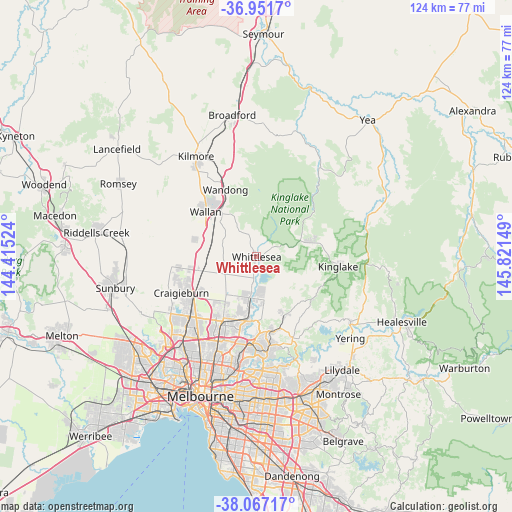
Whittlesea GPS coordinates[2]
37° 30' 41.472" South, 145° 7' 6.096" East
| Map corner | latitude | longitude |
|---|---|---|
| Upper-left | -36.9517°, | 144.41524° |
| Center: | -37.51152°, | 145.11836° |
| Lower-right: | -38.06717°, | 145.82149° |
| Map W x H: | 124×124 km | = 77.1×77.1mi |
| max Lat: | -10.58257° ⇑82.6% North |
| Whittlesea: | -37.51152° |
| min Lat: | ⇓17.4% South -43.31423° |
| min Long | Whittlesea | max Long |
| 113.53327° | 145.11836° | 153.61246° |
| W 36%⇐ | ⇒64% E |
Elevation
Elevation of Whittlesea is 198 m = 650 ft, and this is 76 m = 249 ft above average elevation for this country.
| Max E: |
1715 m = 5627 ft | 18.4% |
| Whittlesea | 198 m 650 ft | |
| Avg. | 122 m = 400 ft | |
Min E: |
-2 m = -7 ft | 81.6% |
See also: Australia elevation on elevation.city.
Geographical zone
Whittlesea is located in South temperate zone (between Tropic of Capricorn and the Antarctic Circle). Distance of this Southern Tropic circle is 1565 km =972.4 mi to North.| Distance of | km | miles | from Whittlesea |
|---|---|---|---|
| Equator | 4170.9 | 2591.7 | to North |
| Tropic Capricorn | 1565 | 972.4 | to North |
| Antarctic Circle | 3230.3 | 2007.2 | to South |
| South Pole | 5836.2 | 3626.4 | to South |


Nearby cities:
15 places around Whittlesea: (largest is in red/bold)
• Beveridge
12.3 km =7.6 mi,  284°
284°
• Cottles Bridge
14.1 km =8.8 mi,  138°
138°
• Doreen
10.2 km =6.3 mi,  164°
164°
• Eden Park
4.4 km =2.7 mi,  315°
315°
• Epping
17.1 km =10.6 mi,  205°
205°
• Hurstbridge
15.9 km =9.9 mi, 155°
• Kinglake West
11.3 km =7 mi,  63°
63°
• Mernda
10.1 km =6.3 mi,  191°
191°
• Plenty
17.3 km =10.7 mi,  180°
180°
• Saint Andrews
16.9 km =10.5 mi,  126°
126°
• South Morang
15.5 km =9.6 mi, 185°
• Wallan
16.3 km =10.1 mi,  310°
310°
• Wandong
17.3 km =10.7 mi,  333°
333°
• Wollert
11 km =6.8 mi,  223°
223°
• Yarrambat
14.1 km =8.8 mi,  174°
174°
Sources, notices
• [Note1] Compared only with cities in Australia existing in our database
• [Src1] Map data: © OpenStreetMap contributors (CC-BY-SA)
• [Src2] Other city data from geonames.org with taken over terms of usage.
• [Src3] Geographical zone / Annual Mean Temperature by Robert A. Rohde @ Wikipedia
