Beveridge geodata
Beveridge (Victoria) is a section of populated place; located in Australia in Australia/Melbourne (GMT+11) time zone. With population of 2,320 people, there are 2681 cities with bigger population in this country. Compared to other cities in Australia, 82.5% of cities are located further ↑North; 66.7% of cities are located further →East and 86.3% of cities have lower elevation than Beveridge. Note1


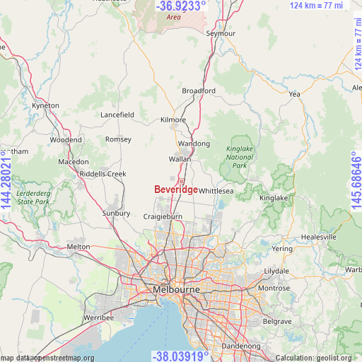
Beveridge GPS coordinates[2]
37° 28' 59.988" South, 144° 58' 59.988" East
| Map corner | latitude | longitude |
|---|---|---|
| Upper-left | -36.9233°, | 144.28021° |
| Center: | -37.48333°, | 144.98333° |
| Lower-right: | -38.03919°, | 145.68646° |
| Map W x H: | 124.1×124.1 km | = 77.1×77.1mi |
| max Lat: | -10.58257° ⇑82.5% North |
| Beveridge: | -37.48333° |
| min Lat: | ⇓17.5% South -43.31423° |
| min Long | Beveridge | max Long |
| 113.53327° | 144.98333° | 153.61246° |
| W 33.3%⇐ | ⇒66.7% E |
Elevation
Elevation of Beveridge is 273 m = 896 ft, and this is 151 m = 495 ft above average elevation for this country.
| Max E: |
1715 m = 5627 ft | 13.7% |
| Beveridge | 273 m 896 ft | |
| Avg. | 122 m = 400 ft | |
Min E: |
-2 m = -7 ft | 86.3% |
See also: Australia elevation on elevation.city.
Geographical zone
Beveridge is located in South temperate zone (between Tropic of Capricorn and the Antarctic Circle). Distance of this Southern Tropic circle is 1561.8 km =970.5 mi to North.| Distance of | km | miles | from Beveridge |
|---|---|---|---|
| Equator | 4167.8 | 2589.8 | to North |
| Tropic Capricorn | 1561.8 | 970.5 | to North |
| Antarctic Circle | 3233.4 | 2009.1 | to South |
| South Pole | 5839.3 | 3628.4 | to South |


Nearby cities:
15 places around Beveridge: (largest is in red/bold)
• Campbellfield
20.2 km =12.6 mi,  185°
185°
• Coolaroo
19.8 km =12.3 mi, 192°
• Craigieburn
13.3 km =8.3 mi, 192°
• Doreen
19.6 km =12.2 mi,  131°
131°
• Eden Park
8.8 km =5.5 mi,  90°
90°
• Epping
19 km =11.8 mi,  166°
166°
• Greenvale
19.6 km =12.2 mi,  211°
211°
• Meadow Heights
19.5 km =12.1 mi,  197°
197°
• Mernda
16.4 km =10.2 mi,  142°
142°
• Mickleham
9.3 km =5.8 mi,  230°
230°
• Roxburgh Park
16.6 km =10.3 mi, 197°
• Wallan
7.5 km =4.7 mi,  356°
356°
• Wandong
13.1 km =8.1 mi,  19°
19°
• Whittlesea
12.3 km =7.6 mi,  104°
104°
• Wollert
12 km =7.5 mi,  158°
158°
Sources, notices
• [Note1] Compared only with cities in Australia existing in our database
• [Src1] Map data: © OpenStreetMap contributors (CC-BY-SA)
• [Src2] Other city data from geonames.org with taken over terms of usage.
• [Src3] Geographical zone / Annual Mean Temperature by Robert A. Rohde @ Wikipedia
