Kinglake West geodata
Kinglake West (Victoria) is a section of populated place; located in Australia in Australia/Melbourne (GMT+11) time zone. With population of 1,122 people, there are 3671 cities with bigger population in this country. Compared to other cities in Australia, 82.4% of cities are located further ↑North; 62.3% of cities are located further →East and 93.3% of cities have lower elevation than Kinglake West. Note1


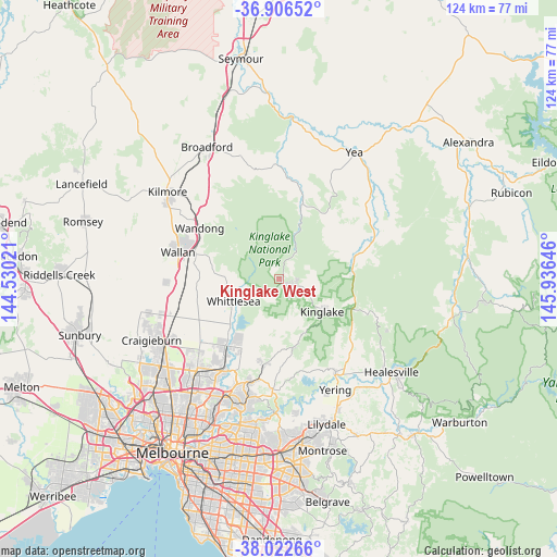
Kinglake West GPS coordinates[2]
37° 28' 0.012" South, 145° 13' 59.988" East
| Map corner | latitude | longitude |
|---|---|---|
| Upper-left | -36.90652°, | 144.53021° |
| Center: | -37.46667°, | 145.23333° |
| Lower-right: | -38.02266°, | 145.93646° |
| Map W x H: | 124.1×124.1 km | = 77.1×77.1mi |
| max Lat: | -10.58257° ⇑82.4% North |
| Kinglake West: | -37.46667° |
| min Lat: | ⇓17.6% South -43.31423° |
| min Long | Kinglake West | max Long |
| 113.53327° | 145.23333° | 153.61246° |
| W 37.7%⇐ | ⇒62.3% E |
Elevation
Elevation of Kinglake West is 492 m = 1614 ft, and this is 370 m = 1214 ft above average elevation for this country.
| Max E: |
1715 m = 5627 ft | 6.7% |
| Kinglake West | 492 m 1614 ft | |
| Avg. | 122 m = 400 ft | |
Min E: |
-2 m = -7 ft | 93.3% |
See also: Australia elevation on elevation.city.
Geographical zone
Kinglake West is located in South temperate zone (between Tropic of Capricorn and the Antarctic Circle). Distance of this Southern Tropic circle is 1560 km =969.3 mi to North.| Distance of | km | miles | from Kinglake West |
|---|---|---|---|
| Equator | 4165.9 | 2588.6 | to North |
| Tropic Capricorn | 1560 | 969.3 | to North |
| Antarctic Circle | 3235.3 | 2010.3 | to South |
| South Pole | 5841.2 | 3629.6 | to South |


Nearby cities:
15 places around Kinglake West: (largest is in red/bold)
• Beveridge
22.1 km =13.7 mi,  265°
265°
• Cottles Bridge
15.6 km =9.7 mi,  183°
183°
• Doreen
16.5 km =10.3 mi,  206°
206°
• Eden Park
13.4 km =8.3 mi,  262°
262°
• Flowerdale
17.3 km =10.7 mi,  30°
30°
• Hurstbridge
19.8 km =12.3 mi,  190°
190°
• Kinglake
11.9 km =7.4 mi,  128°
128°
• Mernda
19.2 km =11.9 mi,  219°
219°
• Panton Hill
19.4 km =12.1 mi, 178°
• Saint Andrews
15.4 km =9.6 mi,  167°
167°
• Wandong
20.7 km =12.9 mi,  300°
300°
• Wattleglen
22.7 km =14.1 mi, 191°
• Whittlesea
11.3 km =7 mi,  243°
243°
• Wollert
21.9 km =13.6 mi,  233°
233°
• Yarrambat
20.9 km =13 mi,  204°
204°
Sources, notices
• [Note1] Compared only with cities in Australia existing in our database
• [Src1] Map data: © OpenStreetMap contributors (CC-BY-SA)
• [Src2] Other city data from geonames.org with taken over terms of usage.
• [Src3] Geographical zone / Annual Mean Temperature by Robert A. Rohde @ Wikipedia
