Werribee geodata
Werribee (Victoria) is a section of populated place; located in Australia in Australia/Melbourne (GMT+11) time zone. With population of 40,143 people, there are 38 cities with bigger population in this country. Compared to other cities in Australia, 90.5% of cities are located further ↑North; 69.7% of cities are located further →East and 64.8% of cities have higher elevation than Werribee. Note1


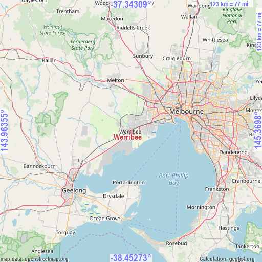
Werribee GPS coordinates[2]
37° 54' 0" South, 144° 40' 0.012" East
| Map corner | latitude | longitude |
|---|---|---|
| Upper-left | -37.34309°, | 143.96355° |
| Center: | -37.9°, | 144.66667° |
| Lower-right: | -38.45273°, | 145.3698° |
| Map W x H: | 123.4×123.4 km | = 76.7×76.7mi |
| max Lat: | -10.58257° ⇑90.5% North |
| Werribee: | -37.9° |
| min Lat: | ⇓9.5% South -43.31423° |
| min Long | Werribee | max Long |
| 113.53327° | 144.66667° | 153.61246° |
| W 30.3%⇐ | ⇒69.7% E |
Elevation
Elevation of Werribee is 27 m = 89 ft, and this is 95 m = 312 ft below average elevation for this country.
| Max E: |
1715 m = 5627 ft | 64.8% |
| Avg. | 122 m = 400 ft | |
| Werribee | 27 m = 89 ft | |
Min E: |
-2 m = -7 ft | 35.2% |
See also: Werribee elevation on elevation.city.
Geographical zone
Werribee is located in South temperate zone (between Tropic of Capricorn and the Antarctic Circle). Distance of this Southern Tropic circle is 1608.2 km =999.3 mi to North.| Distance of | km | miles | from Werribee |
|---|---|---|---|
| Equator | 4214.1 | 2618.5 | to North |
| Tropic Capricorn | 1608.2 | 999.3 | to North |
| Antarctic Circle | 3187.1 | 1980.4 | to South |
| South Pole | 5793 | 3599.6 | to South |


Nearby cities:
15 places around Werribee: (largest is in red/bold)
• Altona
14.8 km =9.2 mi,  76°
76°
• Altona Meadows
10.4 km =6.5 mi, 80°
• Derrimut
15 km =9.3 mi,  37°
37°
• Eynesbury
13.7 km =8.5 mi,  323°
323°
• Hoppers Crossing
3.5 km =2.2 mi,  56°
56°
• Laverton
10 km =6.2 mi, 64°
• Mount Cottrell
11.8 km =7.3 mi, 321°
• Point Cook
7.6 km =4.7 mi,  102°
102°
• Seabrook
8.3 km =5.2 mi, 75°
• Seaholme
16.2 km =10.1 mi, 75°
• Tarneit
7.1 km =4.4 mi,  354°
354°
• Truganina
11.8 km =7.3 mi, 38°
• Werribee South
6.9 km =4.3 mi,  140°
140°
• Williams Landing
8 km =5 mi, 57°
• Wyndham Vale
3.9 km =2.4 mi,  284°
284°
Sources, notices
• [Note1] Compared only with cities in Australia existing in our database
• [Src1] Map data: © OpenStreetMap contributors (CC-BY-SA)
• [Src2] Other city data from geonames.org with taken over terms of usage.
• [Src3] Geographical zone / Annual Mean Temperature by Robert A. Rohde @ Wikipedia
