Tarneit geodata
Tarneit (Victoria) is a section of populated place; located in Australia in Australia/Melbourne (GMT+11) time zone. With population of 34,372 people, there are 50 cities with bigger population in this country. Compared to other cities in Australia, 88.9% of cities are located further ↑North; 69.7% of cities are located further →East and 59.2% of cities have higher elevation than Tarneit. Note1


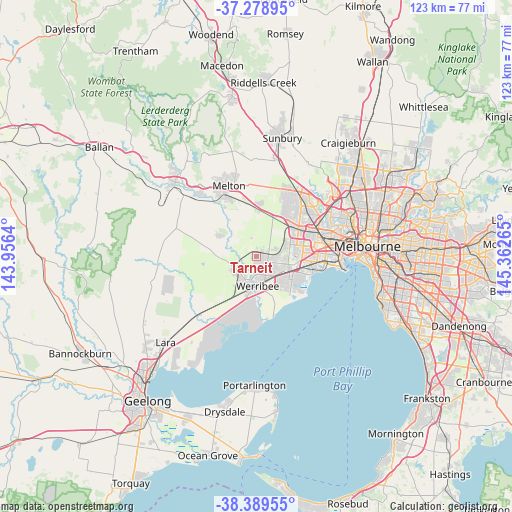
Tarneit GPS coordinates[2]
37° 50' 10.824" South, 144° 39' 34.272" East
| Map corner | latitude | longitude |
|---|---|---|
| Upper-left | -37.27895°, | 143.9564° |
| Center: | -37.83634°, | 144.65952° |
| Lower-right: | -38.38955°, | 145.36265° |
| Map W x H: | 123.5×123.5 km | = 76.7×76.7mi |
| max Lat: | -10.58257° ⇑88.9% North |
| Tarneit: | -37.83634° |
| min Lat: | ⇓11.1% South -43.31423° |
| min Long | Tarneit | max Long |
| 113.53327° | 144.65952° | 153.61246° |
| W 30.3%⇐ | ⇒69.7% E |
Elevation
Elevation of Tarneit is 33 m = 108 ft, and this is 89 m = 292 ft below average elevation for this country.
| Max E: |
1715 m = 5627 ft | 59.2% |
| Avg. | 122 m = 400 ft | |
| Tarneit | 33 m = 108 ft | |
Min E: |
-2 m = -7 ft | 40.8% |
See also: Australia elevation on elevation.city.
Geographical zone
Tarneit is located in South temperate zone (between Tropic of Capricorn and the Antarctic Circle). Distance of this Southern Tropic circle is 1601.1 km =994.9 mi to North.| Distance of | km | miles | from Tarneit |
|---|---|---|---|
| Equator | 4207 | 2614.1 | to North |
| Tropic Capricorn | 1601.1 | 994.9 | to North |
| Antarctic Circle | 3194.2 | 1984.8 | to South |
| South Pole | 5800.1 | 3604 | to South |


Nearby cities:
15 places around Tarneit: (largest is in red/bold)
• Altona Meadows
12.1 km =7.5 mi,  115°
115°
• Deer Park
12.1 km =7.5 mi,  50°
50°
• Derrimut
10.9 km =6.8 mi,  63°
63°
• Eynesbury
8.5 km =5.3 mi,  298°
298°
• Hoppers Crossing
6.3 km =3.9 mi,  145°
145°
• Laverton
10.1 km =6.3 mi,  106°
106°
• Mount Cottrell
7 km =4.3 mi,  288°
288°
• Point Cook
11.9 km =7.4 mi,  137°
137°
• Ravenhall
11.3 km =7 mi, 45°
• Rockbank
11.5 km =7.1 mi,  4°
4°
• Seabrook
10 km =6.2 mi, 119°
• Truganina
8.2 km =5.1 mi,  74°
74°
• Werribee
7.1 km =4.4 mi,  174°
174°
• Williams Landing
7.9 km =4.9 mi, 111°
• Wyndham Vale
6.9 km =4.3 mi,  207°
207°
Sources, notices
• [Note1] Compared only with cities in Australia existing in our database
• [Src1] Map data: © OpenStreetMap contributors (CC-BY-SA)
• [Src2] Other city data from geonames.org with taken over terms of usage.
• [Src3] Geographical zone / Annual Mean Temperature by Robert A. Rohde @ Wikipedia
