Warrenheip geodata
Warrenheip (Victoria) is a section of populated place; located in Australia in Australia/Melbourne (GMT+11) time zone. With population of 689 people, there are 4340 cities with bigger population in this country. Compared to other cities in Australia, 83.2% of cities are located further ↑North; 72.5% of cities are located further →East and 94% of cities have lower elevation than Warrenheip. Note1


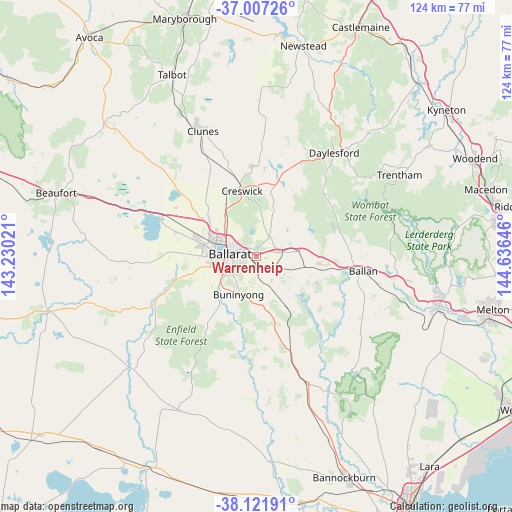
Warrenheip GPS coordinates[2]
37° 34' 0.012" South, 143° 55' 59.988" East
| Map corner | latitude | longitude |
|---|---|---|
| Upper-left | -37.00726°, | 143.23021° |
| Center: | -37.56667°, | 143.93333° |
| Lower-right: | -38.12191°, | 144.63646° |
| Map W x H: | 123.9×123.9 km | = 77×77mi |
| max Lat: | -10.58257° ⇑83.2% North |
| Warrenheip: | -37.56667° |
| min Lat: | ⇓16.8% South -43.31423° |
| min Long | Warrenheip | max Long |
| 113.53327° | 143.93333° | 153.61246° |
| W 27.5%⇐ | ⇒72.5% E |
Elevation
Elevation of Warrenheip is 543 m = 1781 ft, and this is 421 m = 1381 ft above average elevation for this country.
| Max E: |
1715 m = 5627 ft | 6% |
| Warrenheip | 543 m 1781 ft | |
| Avg. | 122 m = 400 ft | |
Min E: |
-2 m = -7 ft | 94% |
See also: Australia elevation on elevation.city.
Geographical zone
Warrenheip is located in South temperate zone (between Tropic of Capricorn and the Antarctic Circle). Distance of this Southern Tropic circle is 1571.1 km =976.2 mi to North.| Distance of | km | miles | from Warrenheip |
|---|---|---|---|
| Equator | 4177 | 2595.5 | to North |
| Tropic Capricorn | 1571.1 | 976.2 | to North |
| Antarctic Circle | 3224.2 | 2003.4 | to South |
| South Pole | 5830 | 3622.6 | to South |


Nearby cities:
15 places around Warrenheip: (largest is in red/bold)
• Ballarat
7.4 km =4.6 mi,  270°
270°
• Ballarat Central
7.3 km =4.5 mi, 274°
• Ballarat East
5.9 km =3.7 mi, 270°
• Ballarat North
6.6 km =4.1 mi,  295°
295°
• Black Hill
6.2 km =3.9 mi,  287°
287°
• Brown Hill
2.7 km =1.7 mi,  324°
324°
• Canadian
5 km =3.1 mi,  258°
258°
• Eureka
4.5 km =2.8 mi, 272°
• Golden Point
5.8 km =3.6 mi, 260°
• Invermay
7.2 km =4.5 mi, 320°
• Lake Wendouree
7.8 km =4.8 mi,  283°
283°
• Mount Clear
5.8 km =3.6 mi,  229°
229°
• Mount Pleasant
6.2 km =3.9 mi,  252°
252°
• Nerrina
4.8 km =3 mi, 292°
• Soldiers Hill
6.8 km =4.2 mi, 286°
Sources, notices
• [Note1] Compared only with cities in Australia existing in our database
• [Src1] Map data: © OpenStreetMap contributors (CC-BY-SA)
• [Src2] Other city data from geonames.org with taken over terms of usage.
• [Src3] Geographical zone / Annual Mean Temperature by Robert A. Rohde @ Wikipedia
