Tuggerah geodata
Tuggerah (New South Wales) is a section of populated place; located in Australia in Australia/Sydney (GMT+11) time zone. With population of 922 people, there are 3942 cities with bigger population in this country. Compared to other cities in Australia, 55.4% of cities are located further ↓South; 77.1% of cities are located further ←West and 88.3% of cities have higher elevation than Tuggerah. Note1


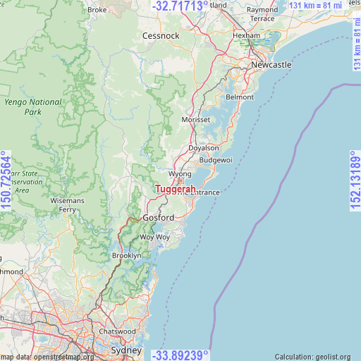
Tuggerah GPS coordinates[2]
33° 18' 24.264" South, 151° 25' 43.536" East
| Map corner | latitude | longitude |
|---|---|---|
| Upper-left | -32.71713°, | 150.72564° |
| Center: | -33.30674°, | 151.42876° |
| Lower-right: | -33.89239°, | 152.13189° |
| Map W x H: | 130.7×130.7 km | = 81.2×81.2mi |
| max Lat: | -10.58257° ⇑44.6% North |
| Tuggerah: | -33.30674° |
| min Lat: | ⇓55.4% South -43.31423° |
| min Long | Tuggerah | max Long |
| 113.53327° | 151.42876° | 153.61246° |
| W 77.1%⇐ | ⇒22.9% E |
Elevation
Elevation of Tuggerah is 10 m = 33 ft, and this is 112 m = 367 ft below average elevation for this country.
| Max E: |
1715 m = 5627 ft | 88.3% |
| Avg. | 122 m = 400 ft | |
| Tuggerah | 10 m = 33 ft | |
Min E: |
-2 m = -7 ft | 11.7% |
See also: Australia elevation on elevation.city.
Geographical zone
Tuggerah is located in South temperate zone (between Tropic of Capricorn and the Antarctic Circle). Distance of this Southern Tropic circle is 1097.4 km =681.9 mi to North.| Distance of | km | miles | from Tuggerah |
|---|---|---|---|
| Equator | 3703.4 | 2301.2 | to North |
| Tropic Capricorn | 1097.4 | 681.9 | to North |
| Antarctic Circle | 3697.8 | 2297.7 | to South |
| South Pole | 6303.7 | 3916.9 | to South |


Nearby cities:
15 places around Tuggerah: (largest is in red/bold)
• Berkeley Vale
4.8 km =3 mi,  174°
174°
• Chittaway Bay
2.3 km =1.4 mi,  177°
177°
• Chittaway Point
2.2 km =1.4 mi,  146°
146°
• Fountaindale
5.2 km =3.2 mi,  209°
209°
• Glenning Valley
5.2 km =3.2 mi, 182°
• Killarney Vale
6.8 km =4.2 mi,  156°
156°
• Mardi
2.9 km =1.8 mi,  299°
299°
• Tacoma
3.8 km =2.4 mi,  56°
56°
• Tuggerawong
5.6 km =3.5 mi, 58°
• Tumbi Vmbi
6.9 km =4.3 mi, 163°
• Wadalba
5.1 km =3.2 mi,  41°
41°
• Warnervale
7 km =4.3 mi,  17°
17°
• Watanobbi
4.4 km =2.7 mi,  352°
352°
• Wyong
2.7 km =1.7 mi, 349°
• Wyongah
6.6 km =4.1 mi, 57°
Sources, notices
• [Note1] Compared only with cities in Australia existing in our database
• [Src1] Map data: © OpenStreetMap contributors (CC-BY-SA)
• [Src2] Other city data from geonames.org with taken over terms of usage.
• [Src3] Geographical zone / Annual Mean Temperature by Robert A. Rohde @ Wikipedia
